IMAGES TAKEN NEAR TO
Wood Terrace, JARROW, NE32 5LY
Introduction
This page details the photographs taken nearby to Wood Terrace, NE32 5LY by members of the Geograph project.
The Geograph project started in 2005 with the aim of publishing, organising and preserving representative images for every square kilometre of Great Britain, Ireland and the Isle of Man.

There are currently over 7.5m images from over14,400 individuals and you can help contribute to the project by visiting https://www.geograph.org.uk
Image Map (Loading...)


Getting Data...Please wait
Leaflet Map data © OpenStreetMap
Images are licensed for reuse under creativecommons.org/licenses/by-sa/2.0
Notes
- Clicking on the map will re-center to the selected point.
- The higher the marker number, the further away the image location is from the centre of the postcode.
Image Listing (19 Images Found)
Images are licensed for reuse under creativecommons.org/licenses/by-sa/2.0
Image
Details
Distance
6
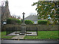
War Memorial
Sadly no wreaths laid yesterday. I can remember wreaths being placed here but I have no idea when this stopped.
Image: © Les Hull
Taken: 9 Nov 2009
0.13 miles
7
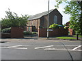
St. Matthew?s RC Church in Jarrow
St. Matthew’s RC Church in Jarrow at the junction of Butchers Bridge Road and York Avenue
Image: © Vin Mullen
Taken: 3 May 2007
0.18 miles
8
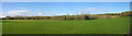
Parkland and nature reserve near Monkton Village
In the 1960/70s this area was known as "The Slaggy". Slag had been dumped here from the iron works and demolished buildings. There was a "crusher" that pulverised rocks and stone and was used as hard core. Now it's a very pleasant parkland area and looks much better than the old "Slaggy"
Image: © Les Hull
Taken: 7 Nov 2009
0.19 miles
9
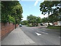
Speed cushions on Monkton Lane
By the junction with Cheviot Road.
Image: © Oliver Dixon
Taken: 14 Jul 2021
0.19 miles
10
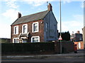
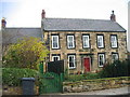
The (former) School House, Bede Burn Road / Dillon Street
Shows the location of Image
Image: © Mike Quinn
Taken: 3 Nov 2009
0.19 miles