IMAGES TAKEN NEAR TO
Lichfield Way, JARROW, NE32 4UL
Introduction
This page details the photographs taken nearby to Lichfield Way, NE32 4UL by members of the Geograph project.
The Geograph project started in 2005 with the aim of publishing, organising and preserving representative images for every square kilometre of Great Britain, Ireland and the Isle of Man.

There are currently over 7.5m images from over14,400 individuals and you can help contribute to the project by visiting https://www.geograph.org.uk
Image Map (Loading...)


Getting Data...Please wait
Leaflet Map data © OpenStreetMap
Images are licensed for reuse under creativecommons.org/licenses/by-sa/2.0
Notes
- Clicking on the map will re-center to the selected point.
- The higher the marker number, the further away the image location is from the centre of the postcode.
Image Listing (4 Images Found)
Images are licensed for reuse under creativecommons.org/licenses/by-sa/2.0
Image
Details
Distance
2
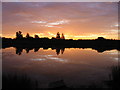
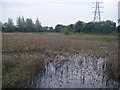
Sunrise over the Lakeside fishery, 6:32am
Image: © P Glenwright
Taken: 5 Sep 2004
0.21 miles
3
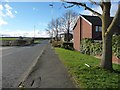
Durham Drive, Fellgate, looking west
Durham Drive is the peripheral road round the estate. Vehicle access to most houses comes from cul-de-sacs off the main road.
Image: © Christine Johnstone
Taken: 25 Feb 2017
0.24 miles
4
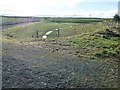
Newly-constructed drainage area, off Durham Drive
On the southern edge of Fellgate. Unmapped. Possible for flood relief?
Image: © Christine Johnstone
Taken: 25 Feb 2017
0.24 miles