IMAGES TAKEN NEAR TO
Thames Avenue, JARROW, NE32 4DS
Introduction
This page details the photographs taken nearby to Thames Avenue, NE32 4DS by members of the Geograph project.
The Geograph project started in 2005 with the aim of publishing, organising and preserving representative images for every square kilometre of Great Britain, Ireland and the Isle of Man.

There are currently over 7.5m images from over14,400 individuals and you can help contribute to the project by visiting https://www.geograph.org.uk
Image Map
Images are licensed for reuse under creativecommons.org/licenses/by-sa/2.0
Notes
- Clicking on the map will re-center to the selected point.
- The higher the marker number, the further away the image location is from the centre of the postcode.
Image Listing (14 Images Found)
Images are licensed for reuse under creativecommons.org/licenses/by-sa/2.0
Image
Details
Distance
5
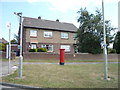
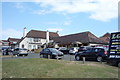
Houses on Kirkstone Avenue, Jarrow
Showing position of Postbox No. NE32 424.
See Image] for postbox.
Image: © JThomas
Taken: 7 Jul 2018
0.17 miles
6
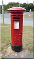
George VI postbox on Kirkstone Avenue, Jarrow
Postbox No. NE32 424.
See Image] for context.
Image: © JThomas
Taken: 7 Jul 2018
0.17 miles
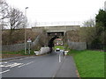
8
Railway bridge over Hedworth Lane, Hedworth, Jarrow
Image: © JThomas
Taken: 7 Jul 2018
0.19 miles
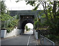
10
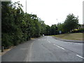
Roman Road, Primrose, Jarrow
Looking east on the B1516.
Image: © JThomas
Taken: 7 Jul 2018
0.22 miles