IMAGES TAKEN NEAR TO
Bilton Hall Road, JARROW, NE32 3ST
Introduction
This page details the photographs taken nearby to Bilton Hall Road, NE32 3ST by members of the Geograph project.
The Geograph project started in 2005 with the aim of publishing, organising and preserving representative images for every square kilometre of Great Britain, Ireland and the Isle of Man.

There are currently over 7.5m images from over14,400 individuals and you can help contribute to the project by visiting https://www.geograph.org.uk
Image Map (Loading...)


Getting Data...Please wait
Leaflet Map data © OpenStreetMap
Images are licensed for reuse under creativecommons.org/licenses/by-sa/2.0
Notes
- Clicking on the map will re-center to the selected point.
- The higher the marker number, the further away the image location is from the centre of the postcode.
Image Listing (78 Images Found)
Images are licensed for reuse under creativecommons.org/licenses/by-sa/2.0
Image
Details
Distance
1
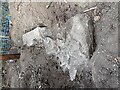
Foundation stone
We think we’ve discovered the foundation stone of an old 1800 bridge that crossed the Newcastle to South Shields train line. We had been told about the bridge historically leading to a farm (Lake House Farm), Jarrow. Unfortunately, the bridge was knocked down in the 1960s to make way for a road during the building of the Tyne tunnel.
Image: © Justine Currie
Taken: 6 Aug 2022
0.07 miles
2
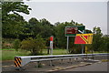
Signs by the A19
There used to be a roundabout ahead but the road layout has changed. The temporary sign relates to the Great North Run but has a suspect spelling of South Sheilds (sic).
Image: © Bill Boaden
Taken: 16 Sep 2011
0.10 miles
3
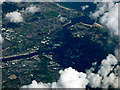
Tynemouth from the air
Jarrow is in the foreground. Viewed from an Edinburgh bound flight from Prague.
Image: © Thomas Nugent
Taken: 18 Aug 2017
0.12 miles
4
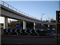
Tyne Tunnel Approach Roundabout
Busy roundabout straddles River Don.
Image: © MSX
Taken: 12 Nov 2005
0.12 miles
5
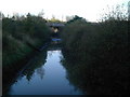
River Don
Recently revamped parkland surrounds this fragrant waterway in "Bede's World".
Image: © MSX
Taken: 12 Nov 2005
0.12 miles
7
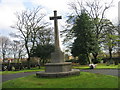
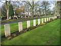
War Memorial in Jarrow Cemetery
This memorial is for the Jarrow Soldiers who died in The Great War (1914-18).
Sadly no wreaths were placed here yesterday which is puzzling since Remembrance Day Crosses were placed at War Graves nearby.
Image: © Les Hull
Taken: 9 Nov 2009
0.15 miles
8
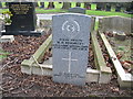
Commonwealth War Grave in Jarrow Cemetery (WW1-15)
William Herbert Donnelly.
Viewed on picture looking West.
http://www.cwgc.org/
Image: © Vin Mullen
Taken: 26 Jan 2007
0.16 miles
9
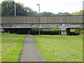
The River Don Path and the A19.
The River Don Path runs up the River Don for 6 miles from the River Tyne at Jarrow to West Boldon. Here it passes under the A19 with not a great deal of headroom!
Image: © Oliver Dixon
Taken: 30 Sep 2015
0.16 miles
10
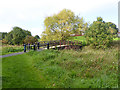
Footbridge over the River Don
A tranquil scene in the shadow of the A19. The River Don Path and Bedes Way runs up the River Don for 6 miles from the River Tyne at Jarrow to West Boldon; Bedes Way continues to the sea at Monkwearmouth
Image: © Oliver Dixon
Taken: 30 Sep 2015
0.16 miles