IMAGES TAKEN NEAR TO
Bishop Crescent, JARROW, NE32 3QB
Introduction
This page details the photographs taken nearby to Bishop Crescent, NE32 3QB by members of the Geograph project.
The Geograph project started in 2005 with the aim of publishing, organising and preserving representative images for every square kilometre of Great Britain, Ireland and the Isle of Man.

There are currently over 7.5m images from over14,400 individuals and you can help contribute to the project by visiting https://www.geograph.org.uk
Image Map
Images are licensed for reuse under creativecommons.org/licenses/by-sa/2.0
Notes
- Clicking on the map will re-center to the selected point.
- The higher the marker number, the further away the image location is from the centre of the postcode.
Image Listing (92 Images Found)
Images are licensed for reuse under creativecommons.org/licenses/by-sa/2.0
Image
Details
Distance
1
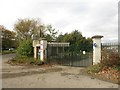
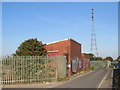
Industrial gateway, Jarrow Riverside
A gateway into an industrial site on the Jarrow riverside.
Image: © Graham Robson
Taken: 7 Oct 2017
0.07 miles
2
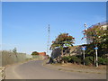
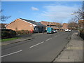
Curlew Road, Jarrow
Curlew Road is a short road in Jarrow. The small blue sign to the right of the image indicates that it is on the route of National Cycle Network route 14.
Image: © Malc McDonald
Taken: 20 Sep 2019
0.07 miles
3
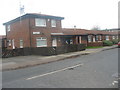
Curran House Mews
Curran House Mews (Pensioners Sheltered Accommodation) in Saxon Way, Jarrow.
It was named after the first Labour MP for Jarrow, Pete Curran.
Who held the seat from 1907 until his death in 1910.
He had won the seat at the bye election in 1907 brought on by the death of Jarrow's very first MP (from 1885 to 1907) the famous shipbuilder Charles Mark Palmer (Liberal).
Image: © Vin Mullen
Taken: 19 Nov 2009
0.07 miles
4
Sea Cadets in Jarrow
Sea Cadets T.S. Raleigh in Curlew Road in Jarrow
Image: © Vin Mullen
Taken: 22 Aug 2006
0.11 miles
5
Curlew Road, Jarrow
Curlew Road is a short road in Jarrow, providing access to industrial sites. It forms part of National Cycle Network route 14.
Image: © Malc McDonald
Taken: 20 Sep 2019
0.11 miles
6
Abbey Drive in Jarrow
Abbey Drive in Jarrow.
Image: © Vin Mullen
Taken: 1 Feb 2008
0.13 miles
7

Abbey News, Abbey Drive
Shows the location of Image
Image: © Mike Quinn
Taken: 3 Nov 2009
0.13 miles
8
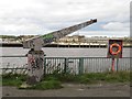
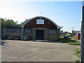
Disused boat hoist, Jarrow riverside
A disused crane once used for lifting small boats into and out of the River Tyne stands on the riverside near the centre of Jarrow.
Image: © Graham Robson
Taken: 7 Oct 2017
0.13 miles
9
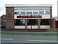
Bede's Ale House in Jarrow
The Bede's Ale House on the corner of Priory Road and Cloister Walk in Jarrow (demolished late 2003)
Private flats have since been built in its place.
It had only been under that name for a few years
From the late 1960s when it was built, till about 2001 it went under the name of The Duke of Wellington ('the juke')
As a matter of interest the original Duke of Wellington this pub replaced late 1960s was situated round the corner in High Street a few hundred yards away (that part of High Street is now renamed Cloister Walk)
Image: © Vin Mullen
Taken: 1 Aug 2003
0.14 miles
10
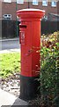
Edward VIII postbox, Abbey Drive
Image: © Mike Quinn
Taken: 3 Nov 2009
0.14 miles