IMAGES TAKEN NEAR TO
Pauls Way, JARROW, NE32 3HD
Introduction
This page details the photographs taken nearby to Pauls Way, NE32 3HD by members of the Geograph project.
The Geograph project started in 2005 with the aim of publishing, organising and preserving representative images for every square kilometre of Great Britain, Ireland and the Isle of Man.

There are currently over 7.5m images from over14,400 individuals and you can help contribute to the project by visiting https://www.geograph.org.uk
Image Map (Loading...)


Getting Data...Please wait
Leaflet Map data © OpenStreetMap
Images are licensed for reuse under creativecommons.org/licenses/by-sa/2.0
Notes
- Clicking on the map will re-center to the selected point.
- The higher the marker number, the further away the image location is from the centre of the postcode.
Image Listing (30 Images Found)
Images are licensed for reuse under creativecommons.org/licenses/by-sa/2.0
Image
Details
Distance
1
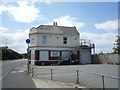
Little Jems Nursery
On Swinburne Street.
Looks like a former public house.
Image: © JThomas
Taken: 7 Jul 2018
0.05 miles
2
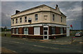
The Alkali Inn, Jarrow
A Public House with an unusual name on the A185 Swinburne Street, Jarrow, South Tyneside.
Image: © Road Engineer
Taken: 4 Nov 2007
0.05 miles
3
Alkali Business Centre
Formerly the Alkali public house, now offices.
See Vin Mullen's earlier shot Image
Image: © Peter McDermott
Taken: 19 Jun 2011
0.05 miles
4
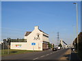
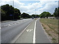
Swinburne Street, near Jarrow
Swinburne Street is on the route of the A185. The pavements are shared by pedestrians and cyclists, and form part of National Cycle Network route 14.
Little Jems nursery occupies a building which was previously a pub. The pub traded as The Alkali, and also for a time as the Zenith Arms. Older images of the building, in use as a pub and as a business centre, are here:
Image
Image
Image
Image
Image: © Malc McDonald
Taken: 20 Sep 2019
0.05 miles
5
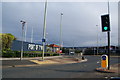
One entrance to the Port of Tyne
The port covers a large area and has more than one entrance.
Image: © Bill Boaden
Taken: 18 Sep 2011
0.08 miles
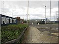
6
Port of Tyne gatehouse, near Jarrow
An entrance into the Port of Tyne near Jarrow.
Image: © Malc McDonald
Taken: 20 Sep 2019
0.09 miles
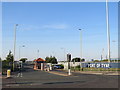
7
Entrance to the Port of Tyne
One of the main vehicular entrances into the secure area which houses the Port of Tyne's facilities on South Tyneside.
Image: © Graham Robson
Taken: 7 Oct 2017
0.09 miles
8
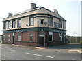
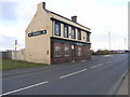
Alkali in Jarrow
Alkali in Swinburne Street Jarrow (opened 1857)
Originally the Alkali then renamed the Zenith
It has now reverted back to the Alkali
Image: © Vin Mullen
Taken: 5 Aug 2003
0.09 miles
9
National Cycle Route 14, East Jarrow
Looking south west beside Swinburne Street (A185).
Image: © JThomas
Taken: 7 Jul 2018
0.09 miles
10
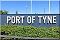
Port of Tyne sign
At the entrance, an annoying 30m from the grid line.
Image: © Richard Webb
Taken: 18 Jun 2013
0.10 miles