IMAGES TAKEN NEAR TO
Curlew Road, JARROW, NE32 3DX
Introduction
This page details the photographs taken nearby to Curlew Road, NE32 3DX by members of the Geograph project.
The Geograph project started in 2005 with the aim of publishing, organising and preserving representative images for every square kilometre of Great Britain, Ireland and the Isle of Man.

There are currently over 7.5m images from over14,400 individuals and you can help contribute to the project by visiting https://www.geograph.org.uk
Image Map
Images are licensed for reuse under creativecommons.org/licenses/by-sa/2.0
Notes
- Clicking on the map will re-center to the selected point.
- The higher the marker number, the further away the image location is from the centre of the postcode.
Image Listing (113 Images Found)
Images are licensed for reuse under creativecommons.org/licenses/by-sa/2.0
Image
Details
Distance
1
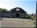
Sea Cadets in Jarrow
Sea Cadets T.S. Raleigh in Curlew Road in Jarrow
Image: © Vin Mullen
Taken: 22 Aug 2006
0.02 miles
2
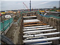
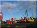
Deep Hole and Pipes for the New Tyne Crossing
Image: © Les Hull
Taken: 24 Jan 2010
0.06 miles
3
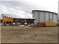
Gas holder demolition, Jarrow
The large and now disused gasometer is in the process of being dismantled and recycled.
Image: © Graham Robson
Taken: 7 Oct 2017
0.06 miles
4
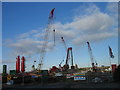
Work on the New Tyne Tunnel Crossing, Jarrow
Image: © Les Hull
Taken: 21 Jan 2009
0.06 miles
5
Work on the New Tyne Tunnel Crossing, Jarrow
Image: © Les Hull
Taken: 21 Jan 2009
0.07 miles
6
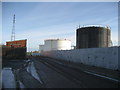
Jarrow Oil Terminal
Shell oil terminal in Jarrow. I was set to take a splendid photo of this, with many tanks featured, but a burly security guard was having none of that - so We will have to make do with this!
Image: © Chris Heaton
Taken: 23 Jan 2007
0.07 miles
7
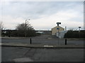
Commercial Road in Jarrow
Commercial Road in Jarrow showing its crossing with Chaytor Street.
At the bottom of the road on the right is the now demolished Gas Light pub.
Image: © Vin Mullen
Taken: 4 Jan 2008
0.08 miles
8
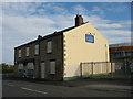
Gas Light Public House in Jarrow
The Gas Light Public House on the corner of Tyne Street and Commercial Road in Jarrow just before it was demolished in 2008.
Notice the pub sign on its gable end.
Also the Street sign on the far corner of the pub
Image: © Vin Mullen
Taken: 2 Sep 2006
0.08 miles
9
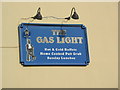
Gas Light Public House sign in Jarrow
The sign that was on the gable end of the Gas Light Public House in Jarrow.
The pub was demolished in 2008.
The sign was viewed from Commercial Road.
The pub was previously called the Tunnel Tavern, and before that in its original name of the Commercial Hotel dating back to the early nineteenth Century
Image: © Vin Mullen
Taken: 2 Sep 2006
0.08 miles
10
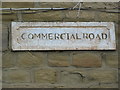
Commercial Road sign in Jarrow
The road sign for Commercial Road in Jarrow that was built into the sandstone brickwork of the Gaslight Public House on the corner of Commercial Road and Tyne Street, which was demolished in 2008.
When it was bedded in to the brickwork in the early nineteenth century the pubs name was the Commercial Hotel
Image: © Vin Mullen
Taken: 2 Sep 2006
0.08 miles