IMAGES TAKEN NEAR TO
Monkridge Court, NEWCASTLE UPON TYNE, NE3 1YW
Introduction
This page details the photographs taken nearby to Monkridge Court, NE3 1YW by members of the Geograph project.
The Geograph project started in 2005 with the aim of publishing, organising and preserving representative images for every square kilometre of Great Britain, Ireland and the Isle of Man.

There are currently over 7.5m images from over14,400 individuals and you can help contribute to the project by visiting https://www.geograph.org.uk
Image Map
Images are licensed for reuse under creativecommons.org/licenses/by-sa/2.0
Notes
- Clicking on the map will re-center to the selected point.
- The higher the marker number, the further away the image location is from the centre of the postcode.
Image Listing (69 Images Found)
Images are licensed for reuse under creativecommons.org/licenses/by-sa/2.0
Image
Details
Distance
1
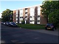
Flats, Alnmouth Drive, Gosforth, Newcastle upon Tyne
One of a group of similar blocks of flats off Alnmouth Drive in South Gosforth.
Image: © Graham Robson
Taken: 15 May 2020
0.01 miles
2
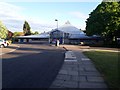
South Gosforth First School
A school providing primary education to local children in Gosforth.
Image: © Graham Robson
Taken: 15 May 2020
0.04 miles
3
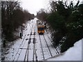
North-bound train heading for South Gosforth
This photograph shows a north-bound Metro train approaching the road bridge at {NZ 251 678} near Dilston Terrace and Rectory Drive. The photograph was taken from the road bridge looking in a southerly direction towards Ilford Road station.
Image: © Philip Barker
Taken: 2 Jan 2010
0.04 miles
4
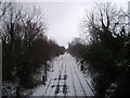
Metro railway lines (view south)
This photograph shows a view of the Metro railway tracks that run between South Gosforth Metro station and Ilford Road Metro station. The picture was taken looking in a southerly direction from the road bridge at {NZ 251 678} just after a recent fall of snow in early January. A north-bound train has just left Ilford Road station.
Image: © Philip Barker
Taken: 2 Jan 2010
0.05 miles
5

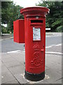
Edward VII postbox, Stoneyhurst Road / Balmoral Terrace, Gosforth, NE3 - royal cipher
See Image
Image: © Mike Quinn
Taken: 17 Aug 2010
0.10 miles
6
Edward VII postbox, Stoneyhurst Road / Balmoral Terrace, Gosforth, NE3
Image: © Mike Quinn
Taken: 17 Aug 2010
0.10 miles
7

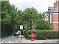
Stoneyhurst Road / Balmoral Terrace, Gosforth, NE3
Shows the location of Image
Image: © Mike Quinn
Taken: 17 Aug 2010
0.10 miles
8

Dilston Terrace
This photograph shows a view of the access path that runs along the front of the houses located in Dilston Terrace near South Gosforth Metro station. This picture was taken looking in a southerly direction towards Rectory Drive. The path runs parallel to the Metro railway track which lies just to the left of the solid wooden-fence that faces the houses. Just through the trees it is possible to see a road bridge that crosses the railway.
Image: © Philip Barker
Taken: 2 Jan 2010
0.12 miles
9
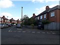
Balmoral Terrace, Gosforth, NE3
Shows the location of Image
Image: © Mike Quinn
Taken: 17 Aug 2010
0.12 miles
10
Dene View, Gosforth
A residential street of mainly semi detached houses in the Gosforth part of Newcastle.
Image: © Graham Robson
Taken: 10 May 2020
0.13 miles