IMAGES TAKEN NEAR TO
Gallalaw Terrace, NEWCASTLE UPON TYNE, NE3 1TD
Introduction
This page details the photographs taken nearby to Gallalaw Terrace, NE3 1TD by members of the Geograph project.
The Geograph project started in 2005 with the aim of publishing, organising and preserving representative images for every square kilometre of Great Britain, Ireland and the Isle of Man.

There are currently over 7.5m images from over14,400 individuals and you can help contribute to the project by visiting https://www.geograph.org.uk
Image Map
Images are licensed for reuse under creativecommons.org/licenses/by-sa/2.0
Notes
- Clicking on the map will re-center to the selected point.
- The higher the marker number, the further away the image location is from the centre of the postcode.
Image Listing (35 Images Found)
Images are licensed for reuse under creativecommons.org/licenses/by-sa/2.0
Image
Details
Distance
1

Roadworks, Killingworth Road, Newcastle upon Tyne
A long running scheme of roadworks, which started in 2017, on Killingworth Road. The scheme has included replacing the metro bridge (this was completed in 2017) and widening the road and improving pedestrian and cycle routes. The scheme has been dogged by delays, but is now in its final stages.
Image: © Graham Robson
Taken: 7 Apr 2020
0.05 miles
2
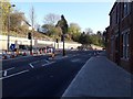
Killingworth Road, Newcastle upon Tyne
As part of the long running roadworks to improve Killingworth Road the pavement has been widened and traffic lights have been installed where the newly widened section of road narrows as it approaches Haddricks Mill.
Image: © Graham Robson
Taken: 7 Apr 2020
0.06 miles
3

Footbridge over the Tyne and Wear Metro
Footbridge linking Holywood Avenue and Hunter's Road over the northern limb of the Tyne and Wear Metro. Longbenton station lies a short way to the east.
Image: © Oliver Dixon
Taken: 4 Dec 2013
0.10 miles
4

Bus stops on Salters Lane
Bus shelters on either side of the busy Salters Lane road which connects Gosforth and Killingworth.
Image: © Graham Robson
Taken: 21 Aug 2016
0.11 miles
5

Houstesteds Gardens, Longbenton
Private housing estate.
Image: © wfmillar
Taken: 13 Jul 2013
0.12 miles


8

The Victory, South Gosforth, Newcastle upon Tyne
A public house on Killingworth Road in South Gosforth.
Image: © Graham Robson
Taken: 2 Apr 2020
0.15 miles
9

The Victory, South Gosforth
A public house in South Gosforth. located close to the busy Haddricks Mill road junction.
Image: © Graham Robson
Taken: 21 Aug 2016
0.15 miles
10

Tyne and West Metro at South Gosforth
The line to the left is the northern branch of the Tyne and Wear Metro, with South Gosforth a short way round to the left out of sight. To the right the line leads to the Gosforth Engine Sheds. The yard in the angle is probably a depot for railway stores.
Image: © Oliver Dixon
Taken: 4 Dec 2013
0.15 miles