IMAGES TAKEN NEAR TO
Church Road, NEWCASTLE UPON TYNE, NE3 1BJ
Introduction
This page details the photographs taken nearby to Church Road, NE3 1BJ by members of the Geograph project.
The Geograph project started in 2005 with the aim of publishing, organising and preserving representative images for every square kilometre of Great Britain, Ireland and the Isle of Man.

There are currently over 7.5m images from over14,400 individuals and you can help contribute to the project by visiting https://www.geograph.org.uk
Image Map
Images are licensed for reuse under creativecommons.org/licenses/by-sa/2.0
Notes
- Clicking on the map will re-center to the selected point.
- The higher the marker number, the further away the image location is from the centre of the postcode.
Image Listing (66 Images Found)
Images are licensed for reuse under creativecommons.org/licenses/by-sa/2.0
Image
Details
Distance
1
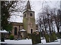
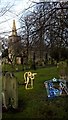
Gravestones in Gosforth Parish Church
This photograph shows a selection of some of the interesting gravestones located in the Parish Church of Gosforth. The picture was taken looking in an easterly direction from just inside the entrance on Church Road.
Image: © Philip Barker
Taken: 2 Jan 2010
0.03 miles
3
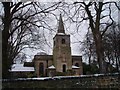
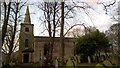
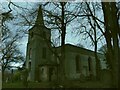
Gosforth Parish Church through the trees
This photograph shows a view of the Parish Church of Gosforth looking through the trees that surround it. The picture was taken looking in an easterly direction from Church Road near the A191 road.
Image: © Philip Barker
Taken: 2 Jan 2010
0.05 miles
4
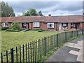
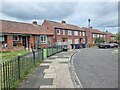
Bungalows on Church Lane
P:ossibly former miner's accommodation.
Image: © Oliver Dixon
Taken: 10 May 2023
0.05 miles
7
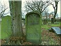
Pigg family memorial, St Nicholas churchyard, Gosforth
The unusual wording caught my eye: 'The burial place of James Pigg of Bulman Village'. The full text is transcribed in his entry on findagrave.com https://www.findagrave.com/memorial/159092845/james-pigg
Bulman Village was the previous name of Gosforth, after Job Bulman (after whom the town's Wetherspoon pub is now named) built Coxlodge Hall in 1796, after making his fortune in India. [Source: https://www.curiousfox.com/vill100/NorthumberlandSmallerVillages_2.html ]
Image: © Stephen Craven
Taken: 4 Dec 2021
0.05 miles
8
Church Lane
So named for the church of Saint Nicholas, South Gosforth, nearby.
Image: © Oliver Dixon
Taken: 10 May 2023
0.05 miles
9
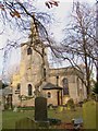
St Nicholas church, Gosforth
Viewed on an early December day (appropriately, the saint's feast day being the 6th December). The present building was erected in 1799 by John Dodds after demolition of an earlier church and takes its dedication from the city's parish church. It was extended in 1820 by John Dobson (a leading architect in Newcastle). It is shown on the earliest OS map of 1864 as a 'stipendiary curacy of Newcastle-upon-Tyne', meaning it was a chapel of ease to the city church three miles away, but by 1897 is shown as a 'Rectory' meaning it had become a parish church with its own incumbent, perhaps in 1882 when the Diocese of Newcastle was formed and the parish church elevated to Cathedral status. Extended again in 1912 and 1950. Listed grade II (list entry 1355218).
Image: © Stephen Craven
Taken: 4 Dec 2021
0.06 miles
10
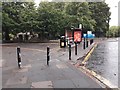
Bus stop, Station Road, Gosforth, Newcastle upon Tyne
A bus stop of east bound services using Station Road, and Metro replacement buses. The bus stop is located at what was once the junction of Church Road and Station Road. The bus stop, bollards and paved area now prevent traffic from using the former junction.
Image: © Graham Robson
Taken: 3 Jun 2020
0.06 miles