IMAGES TAKEN NEAR TO
Manor Close, NEWCASTLE UPON TYNE, NE3 1AP
Introduction
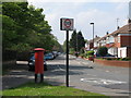
This page details the photographs taken nearby to Manor Close, NE3 1AP by members of the Geograph project.
The Geograph project started in 2005 with the aim of publishing, organising and preserving representative images for every square kilometre of Great Britain, Ireland and the Isle of Man.

There are currently over 7.5m images from over14,400 individuals and you can help contribute to the project by visiting https://www.geograph.org.uk
Image Map
Images are licensed for reuse under creativecommons.org/licenses/by-sa/2.0
Notes
- Clicking on the map will re-center to the selected point.
- The higher the marker number, the further away the image location is from the centre of the postcode.
Image Listing (75 Images Found)
Images are licensed for reuse under creativecommons.org/licenses/by-sa/2.0
Image
Details
Distance
1
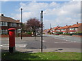
Church Avenue / St. Nicholas Avenue
Shows the location of Image
Image: © Mike Quinn
Taken: 29 Apr 2009
0.05 miles
2
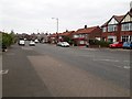
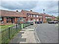
Church Avenue, Gosforth, Newcastle upon Tyne
A road with semi detached houses on either side in Gosforth.
Image: © Graham Robson
Taken: 13 Apr 2020
0.06 miles
3
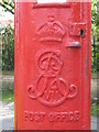
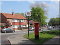
Edward VII postbox, Church Avenue / St. Nicholas Avenue - royal cipher
See Image
Image: © Mike Quinn
Taken: 29 Apr 2009
0.07 miles
4
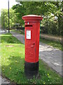
Edward VII postbox, Church Avenue / St. Nicholas Avenue
Image: © Mike Quinn
Taken: 29 Apr 2009
0.07 miles
5
A191 passing through Gosforth
The A191 road passes through Gosforth in a roughly east/west direction. This photograph shows a north-westerly view along a section of this road taken near its junction with Church Avenue. The tall buildings on the horizon are located at the Regent Centre.
Image: © Philip Barker
Taken: 2 Jan 2010
0.07 miles
6
Church Lane
So named for the church of Saint Nicholas, South Gosforth, nearby.
Image: © Oliver Dixon
Taken: 10 May 2023
0.08 miles
7
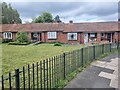
Bungalows on Church Lane
P:ossibly former miner's accommodation.
Image: © Oliver Dixon
Taken: 10 May 2023
0.08 miles
10

Road junction in Gosforth
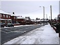
This photograph depicts a typical suburban road junction in south Gosforth. It shows the confluence of Stoneyhurst Road West (on the right) with The Grove (straight ahead). The Grove itself junctions with the A191 a little further along its length. The picture was taken after a recent fall of snow (in early January) looking in a north-easterly direction along The Grove towards the A191 and Gosforth Parish Church.
Image: © Philip Barker
Taken: 2 Jan 2010
0.12 miles