IMAGES TAKEN NEAR TO
Derby Crescent, HEBBURN, NE31 2TP
Introduction
This page details the photographs taken nearby to Derby Crescent, NE31 2TP by members of the Geograph project.
The Geograph project started in 2005 with the aim of publishing, organising and preserving representative images for every square kilometre of Great Britain, Ireland and the Isle of Man.

There are currently over 7.5m images from over14,400 individuals and you can help contribute to the project by visiting https://www.geograph.org.uk
Image Map (Loading...)


Getting Data...Please wait
Leaflet Map data © OpenStreetMap
Images are licensed for reuse under creativecommons.org/licenses/by-sa/2.0
Notes
- Clicking on the map will re-center to the selected point.
- The higher the marker number, the further away the image location is from the centre of the postcode.
Image Listing (17 Images Found)
Images are licensed for reuse under creativecommons.org/licenses/by-sa/2.0
Image
Details
Distance
1
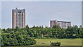
Hebburn New Town
Tower blocks in Hebburn New Town.
Image: © Peter McDermott
Taken: 21 May 2011
0.11 miles
3
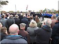
Remembrance Day Crowds, Carr Ellison Park, Hebburn
Image: © Les Hull
Taken: 11 Oct 2018
0.13 miles
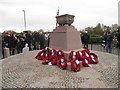

8
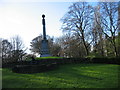
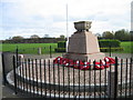
Boer War Memorial in Carr Ellison Park, Hebburn
Six Hebburn men lost their lives in the Boer War.
Five were Privates and one was a Farrier.
Image: © Les Hull
Taken: 7 Nov 2009
0.17 miles
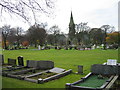
9
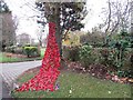
Weeping Tree, Hebburn Cemetery
Made by the Friends of Hebburn Cemetery. Poppies were also placed in bushes and trees in the main drive.
Image: © Les Hull
Taken: 11 Oct 2018
0.18 miles