IMAGES TAKEN NEAR TO
Finchale Road, HEBBURN, NE31 2DA
Introduction
This page details the photographs taken nearby to Finchale Road, NE31 2DA by members of the Geograph project.
The Geograph project started in 2005 with the aim of publishing, organising and preserving representative images for every square kilometre of Great Britain, Ireland and the Isle of Man.

There are currently over 7.5m images from over14,400 individuals and you can help contribute to the project by visiting https://www.geograph.org.uk
Image Map (Loading...)


Getting Data...Please wait
Leaflet Map data © OpenStreetMap
Images are licensed for reuse under creativecommons.org/licenses/by-sa/2.0
Notes
- Clicking on the map will re-center to the selected point.
- The higher the marker number, the further away the image location is from the centre of the postcode.
Image Listing (5 Images Found)
Images are licensed for reuse under creativecommons.org/licenses/by-sa/2.0
Image
Details
Distance
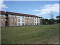
1
Carr Ellison Park
A well kept scenic park in suburban South Tyneside.
Image: © MSX
Taken: 15 Oct 2005
0.04 miles
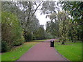
2
St John's Avenue
A very suburban tract near Carr Ellison Park.
Image: © MSX
Taken: 15 Oct 2005
0.04 miles
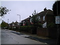
3
Cycle path beside Campbell Park Road, Hebburn
Looking south east.
Image: © JThomas
Taken: 7 Jul 2018
0.22 miles
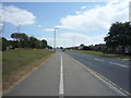
4
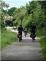
Cyclists on Bowes Railway Path
The Bowes Railway was an old colliery railway which ran from Andrews House, Sunniside to coal staithes at Jarrow. Most of the length of the line has now been converted to a cycle path, designated Regional Route 11 of the National Cycle Network.
Image: © Oliver Dixon
Taken: 14 Jul 2021
0.24 miles