IMAGES TAKEN NEAR TO
Fire Station Houses, Victoria Road West, HEBBURN, NE31 1UD
Introduction
This page details the photographs taken nearby to Fire Station Houses, Victoria Road West, NE31 1UD by members of the Geograph project.
The Geograph project started in 2005 with the aim of publishing, organising and preserving representative images for every square kilometre of Great Britain, Ireland and the Isle of Man.

There are currently over 7.5m images from over14,400 individuals and you can help contribute to the project by visiting https://www.geograph.org.uk
Image Map (Loading...)


Getting Data...Please wait
Leaflet Map data © OpenStreetMap
Images are licensed for reuse under creativecommons.org/licenses/by-sa/2.0
Notes
- Clicking on the map will re-center to the selected point.
- The higher the marker number, the further away the image location is from the centre of the postcode.
Image Listing (5 Images Found)
Images are licensed for reuse under creativecommons.org/licenses/by-sa/2.0
Image
Details
Distance
1
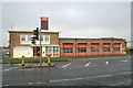
Hebburn fire station
Hebburn fire station, Victoria Road West, Hebburn, Tyne & Wear
Image: © Kevin Hale
Taken: 26 Nov 2006
0.02 miles
2
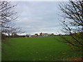
Playing field at South Tyneside College, Hebburn
Image: © Les Hull
Taken: 8 Nov 2009
0.19 miles
4
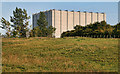
Siemens Reyrolle
The Siemens Reyrolle building at Hebburn.
See also Image
Image: © Peter McDermott
Taken: 30 Jul 2011
0.20 miles
5
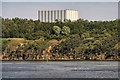
Siemens Reyrolle
The Siemens Reyrolle building at Hebburn.
See also Image
Image: © Peter McDermott
Taken: 30 Jul 2011
0.20 miles