IMAGES TAKEN NEAR TO
Witton Road, HEBBURN, NE31 1SN
Introduction
This page details the photographs taken nearby to Witton Road, NE31 1SN by members of the Geograph project.
The Geograph project started in 2005 with the aim of publishing, organising and preserving representative images for every square kilometre of Great Britain, Ireland and the Isle of Man.

There are currently over 7.5m images from over14,400 individuals and you can help contribute to the project by visiting https://www.geograph.org.uk
Image Map
Images are licensed for reuse under creativecommons.org/licenses/by-sa/2.0
Notes
- Clicking on the map will re-center to the selected point.
- The higher the marker number, the further away the image location is from the centre of the postcode.
Image Listing (20 Images Found)
Images are licensed for reuse under creativecommons.org/licenses/by-sa/2.0
Image
Details
Distance
1
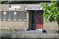
Highline Social Club, Hebburn Colliery
Image: © Richard Webb
Taken: 18 Jun 2013
0.02 miles
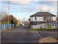
2
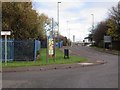
Blackett Street, Hebburn Colliery
At the roundabout junction with Wagonway Road and Windmill Way.
Image: © Andrew Curtis
Taken: 27 Nov 2015
0.07 miles
3
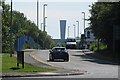
Blackett Street, Hebburn Colliery
View eastwards towards one of the Tyne Tunnel vents. Someone else was taking photographs and was armed with a set of old photographs. Hopefully we will see the results here one day.
Image: © Richard Webb
Taken: 18 Jun 2013
0.08 miles
4
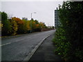
Wagonway Road
Aptly titled road in the middle of Hebburn Colliery.
Image: © MSX
Taken: 15 Oct 2005
0.08 miles
5
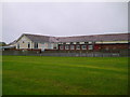
St Aloysious Primary School
Roman Catholic school on Argyle Street, Hebburn.
Image: © MSX
Taken: 15 Oct 2005
0.08 miles
6
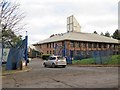
The Eco Centre from Blackett Street
See description here Image
Image: © Andrew Curtis
Taken: 27 Nov 2015
0.09 miles
7
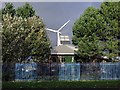
The Eco Centre, Windmill Way, Hebburn Colliery
The Eco Centre was designed and built by Groundwork South Tyneside and Newcastle (STAN) and opened in 1996. The building was a pioneering venture to demonstrate renewable technologies and sustainable design.
Today the Eco Centre remains one of Europe's most sustainable buildings. It is Groundwork South Tyneside and Newcastle’s Trust Headquarters, and is also a professional Business Centre with office space to let.
http://www.groundwork.org.uk/Sites/stan/pages/the-eco-centre
Image: © Andrew Curtis
Taken: 27 Nov 2015
0.10 miles
9
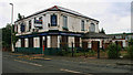
Dougie's Tavern
Dougie's tavern public house in Hebburn.
Image: © Peter McDermott
Taken: 19 Jun 2011
0.15 miles
10
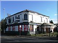
The White Lead, Blackett Street, Hebburn
The White Lead is an English Gastro Restaurant, bar & micro-brewery which opened on 4th October 2013. New life for the former Dougies Tavern Image
‘The White Lead’ comes from original industrial heritage; though originally it was a Victorian pub called The Royal Hotel, it was affectionately known by people in Jarrow and Hebburn from the late 1800s onwards as The White Lead, as many of the properties in the area were covered with white powder from the local lead manufacturing plant. The Tyne Lead Works was on the other side of the road; land still fenced off and unused.
Image: © Andrew Curtis
Taken: 27 Nov 2015
0.16 miles