IMAGES TAKEN NEAR TO
Railway Street, HEBBURN, NE31 1HH
Introduction
This page details the photographs taken nearby to Railway Street, NE31 1HH by members of the Geograph project.
The Geograph project started in 2005 with the aim of publishing, organising and preserving representative images for every square kilometre of Great Britain, Ireland and the Isle of Man.

There are currently over 7.5m images from over14,400 individuals and you can help contribute to the project by visiting https://www.geograph.org.uk
Image Map (Loading...)


Getting Data...Please wait
Leaflet Map data © OpenStreetMap
Images are licensed for reuse under creativecommons.org/licenses/by-sa/2.0
Notes
- Clicking on the map will re-center to the selected point.
- The higher the marker number, the further away the image location is from the centre of the postcode.
Image Listing (5 Images Found)
Images are licensed for reuse under creativecommons.org/licenses/by-sa/2.0
Image
Details
Distance
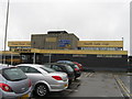
2
Wagonway Road
Aptly titled road in the middle of Hebburn Colliery.
Image: © MSX
Taken: 15 Oct 2005
0.21 miles
3
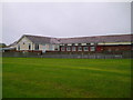
St Aloysious Primary School
Roman Catholic school on Argyle Street, Hebburn.
Image: © MSX
Taken: 15 Oct 2005
0.21 miles
4
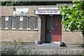
Highline Social Club, Hebburn Colliery
Image: © Richard Webb
Taken: 18 Jun 2013
0.22 miles
5
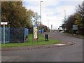
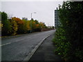
Blackett Street, Hebburn Colliery
At the roundabout junction with Wagonway Road and Windmill Way.
Image: © Andrew Curtis
Taken: 27 Nov 2015
0.25 miles