IMAGES TAKEN NEAR TO
Manorway, NORTH SHIELDS, NE30 4ND
Introduction
This page details the photographs taken nearby to Manorway, NE30 4ND by members of the Geograph project.
The Geograph project started in 2005 with the aim of publishing, organising and preserving representative images for every square kilometre of Great Britain, Ireland and the Isle of Man.

There are currently over 7.5m images from over14,400 individuals and you can help contribute to the project by visiting https://www.geograph.org.uk
Image Map
Images are licensed for reuse under creativecommons.org/licenses/by-sa/2.0
Notes
- Clicking on the map will re-center to the selected point.
- The higher the marker number, the further away the image location is from the centre of the postcode.
Image Listing (265 Images Found)
Images are licensed for reuse under creativecommons.org/licenses/by-sa/2.0
Image
Details
Distance
1
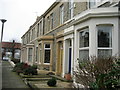
Latimer Street, Tynemouth
Terraced housing which offers substantial accommodation to the occupants
Image: © Chris Heaton
Taken: 26 Dec 2006
0.07 miles
2
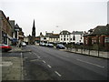
Percy Park Road, Tynemouth
Looking south away from the coast towards the centre of the "village" - although this community is certainly rather larger than the word suggests
Image: © Chris Heaton
Taken: 26 Dec 2006
0.07 miles
3
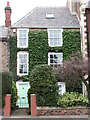
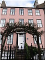
1 Front Street, Tynemouth
Built for the agent of the Duke of Northumberland in the early 19th century, this is a two-storey, four bay house with arched sixteen light sash windows. The arched doorway has a Turkish crescent stone plaque. One of the bays, left of the doorway, is made up of two Victorian windows although not containing the original glass. For a selection of detailed free to download walking routes in the area visit www.northtynesidewalks.co.uk
Image: © Geoff Holland
Taken: 2 Mar 2021
0.08 miles
4
6 Front Street, Tynemouth
This rather grand Victorian house, now divided into a number of apartments, is not a Listed building although it is one of the properties referred to in North Tyneside Council's register of buildings and parks that are of special local architectural and historic interest. For a selection of detailed free to download walking routes in the area visit www.northtynesidewalks.co.uk
Image: © Geoff Holland
Taken: 23 Feb 2021
0.08 miles
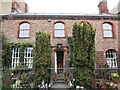
5
2 Front Street, Tynemouth
This is a late 18th century three storey house, the front elevation of which was originally its side elevation. The building was re-fronted in the early 19th century. For a selection of detailed free to download walking routes in the area visit www.northtynesidewalks.co.uk
Image: © Geoff Holland
Taken: 2 Mar 2021
0.08 miles
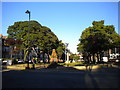
6
Public gardens, Manor Road, NE30
Shows the location of Image
Image: © Mike Quinn
Taken: 13 Sep 2014
0.08 miles
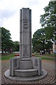
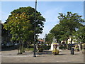
8
War memorial and park, Tynemouth
Between Front Street (left) and Huntingdon Place.
Image: © Richard Vince
Taken: 28 Jun 2018
0.09 miles
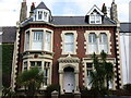
9
Marsden House, 9 Front Street, Tynemouth
Built in the early part of the 18th century, this superb three-storey house with basement is a Grade II Listed building. There are seven stone steps leading up to the central six-panelled door with overlight, set in a Tuscan doorcase with triglyph frieze. For a selection of detailed free to download walking routes in the area visit www.northtynesidewalks.co.uk
Image: © Geoff Holland
Taken: 23 Feb 2021
0.09 miles
10
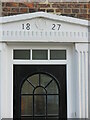
Doorway, Percy Street, Tynemouth
When the first Ordnance Survey Six-Inch map of the area was published in 1865 (surveyed 1858), this part of Percy Street was named as 'Back Street' and continued uninterrupted along what is now St. Oswin's Place. This property stands close to the junction with Percy Park Road and forms part of the historic core of Tynemouth Village. For a selection of detailed free to download walking routes in the area visit www.northtynesidewalks.co.uk
Image: © Geoff Holland
Taken: 23 Feb 2021
0.09 miles