IMAGES TAKEN NEAR TO
Hotspur Street, NORTH SHIELDS, NE30 4EN
Introduction
This page details the photographs taken nearby to Hotspur Street, NE30 4EN by members of the Geograph project.
The Geograph project started in 2005 with the aim of publishing, organising and preserving representative images for every square kilometre of Great Britain, Ireland and the Isle of Man.

There are currently over 7.5m images from over14,400 individuals and you can help contribute to the project by visiting https://www.geograph.org.uk
Image Map
Images are licensed for reuse under creativecommons.org/licenses/by-sa/2.0
Notes
- Clicking on the map will re-center to the selected point.
- The higher the marker number, the further away the image location is from the centre of the postcode.
Image Listing (304 Images Found)
Images are licensed for reuse under creativecommons.org/licenses/by-sa/2.0
Image
Details
Distance

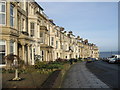
3
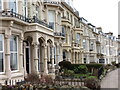
Percy Gardens, Tynemouth
In the mid 19th century Tynemouth was growing in popularity as a commuter village following the opening of the railway link to Newcastle. Seizing upon the opportunity, the then Duke of Northumberland put forward plans for a substantial residential housing development on his land on the north and east edge of the village. The sweeping crescent of Percy Gardens with its grand houses, private gated road, railed communal gardens commanding magnificent views of King Edward's Bay and Tynemouth Priory and Castle was the exclusive showpiece of this development. Plots were leased to individuals who employed their own architects and built their own houses in ones, twos and sometimes in fours in a restrained Victorian style achieving an attractive degree of architectural harmony. Most were built during the 1870s. For a selection of detailed free to download walking routes in the area visit www.northtynesidewalks.co.uk
Image: © Geoff Holland
Taken: 2 Mar 2021
0.05 miles
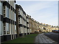
4
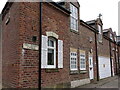
Percy Gardens Cottages, Back Percy Gardens, Tynemouth
This row of buildings first appeared on the Ordnance Survey Six-Inch map of the area in 1898, and was probably built in the 1870s at the same time as the Grand Hotel and the houses in Percy Gardens. The Grand Hotel was initially built in 1872 as a summer residence for the Duchess of Northumberland although in 1877 it was converted into an hotel. One of the many early amenities of the hotel was that of, "good stabling", and that is what these cottages were originally used for. Even to this day, the Grand Hotel boasts that, "Car and motorbike garages are available at 'The Stables Garages' 30 metres from the hotel", a stone's throw from these cottages. For a selection of detailed free to download walking routes in the area visit www.northtynesidewalks.co.uk
Image: © Geoff Holland
Taken: 2 Mar 2021
0.06 miles
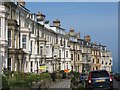
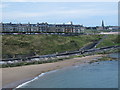
6
Percy Gardens
Impressive houses at Tynemouth Front.
Image: © wfmillar
Taken: 26 Jan 2007
0.06 miles

9
Percy Gardens, NE30, above King Edward's Bay
Image: © Mike Quinn
Taken: 5 Aug 2014
0.07 miles
10

48 Percy Gardens
Used by 5th Northumberland VA Hospital during the First World War.
Image: © Patrick Brennan - donmouth.co.uk
Taken: 28 Sep 2007
0.08 miles