IMAGES TAKEN NEAR TO
Tynemouth Road, NORTH SHIELDS, NE30 4AY
Introduction
This page details the photographs taken nearby to Tynemouth Road, NE30 4AY by members of the Geograph project.
The Geograph project started in 2005 with the aim of publishing, organising and preserving representative images for every square kilometre of Great Britain, Ireland and the Isle of Man.

There are currently over 7.5m images from over14,400 individuals and you can help contribute to the project by visiting https://www.geograph.org.uk
Image Map
Images are licensed for reuse under creativecommons.org/licenses/by-sa/2.0
Notes
- Clicking on the map will re-center to the selected point.
- The higher the marker number, the further away the image location is from the centre of the postcode.
Image Listing (332 Images Found)
Images are licensed for reuse under creativecommons.org/licenses/by-sa/2.0
Image
Details
Distance
1

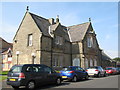
Former station building at Tynemouth
This building is now part of a sheltered housing complex called Mariners Court, but was previously the railway station for Tynemouth, opened in 1847. After the present station was built in 1882, it became a goods station until 1959. An indication of its former status are the shields above the doorway which show the coat of arms of Tynemouth.
Image: © Robert Graham
Taken: 14 Nov 2022
0.02 miles
2

Former railway station on Tynemouth Road
This was originally Oxford Street Station, the first railway station in Tynemouth, opened in 1847. In 1882 it was superseded as a passenger station by a new one on Station Terrace, the present Tynemouth Station. The old one continued as a goods station until 1959. In recent years it was incorporated into a sheltered housing project called Mariners Point.
Image: © Robert Graham
Taken: 14 Nov 2022
0.02 miles
3
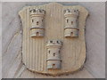
Coat of arms on the first Tynemouth station
See Image
Image: © Mike Quinn
Taken: 13 Sep 2014
0.02 miles
4

Former Tynemouth Railway Station
Opened by the Newcastle and Berwick Railway on 29 March 1847 to the designs of John and Benjamin Green and R Nicholson, the station closed to passengers with the opening of the current Metro Station by the North Eastern Railway on 3 July 1882. The station was retained for goods use until March 1959. Now residential accommodation, the station building is listed, Grade II.
Further information on Disused Stations http://www.disused-stations.org.uk/t/tynemouth_nb/index.shtml
Image: © Anthony Foster
Taken: 15 Aug 2020
0.02 miles
5
The first Tynemouth station
Another view is shown in Image, and info about the building is given on a blue plaque shown in Image (both photos by Alan Heardman).
Image: © Mike Quinn
Taken: 13 Sep 2014
0.02 miles
6

Tynemouth Road
Looking along Tynemouth Road from the junction with Oxford Street.
Image: © DS Pugh
Taken: 10 Aug 2019
0.02 miles
7

Main Passenger Building, Former Tynemouth Station, Oxford Street, Tynemouth
Opened in 1847 and designed for the Newcastle and Berwick Railway Company by architects John and Benjamin Green, who also designed the Theatre Royal in Grey Street, Newcastle upon Tyne, this well kept building now forms part of the Mariner's Point housing development. The street-facing facade of the building has four shields set into the stonework, two of which contain three castles. There is a fine oriel window in the gable peak and the building is Grade II Listed. For a selection of detailed free to download walking routes in the area visit www.northtynesidewalks.co.uk
Image: © Geoff Holland
Taken: 23 Feb 2021
0.03 miles
8
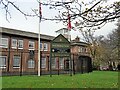
Tynemouth Army Reserve Centre
On Tynemouth Road, coming into the town centre from North Shields. Formally known as the T A Centre (Territorial Army Centre).
Image: © Robert Graham
Taken: 14 Nov 2022
0.03 miles
9
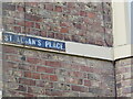
Historic Nameplate, St. Alban's Place, Tynemouth
This original nameplate is a fairly rare historic and attractive detail. For a selection of detailed free to download walking routes in the area visit www.northtynesidewalks.co.uk
Image: © Geoff Holland
Taken: 23 Feb 2021
0.04 miles
10
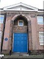
Door and Doorhead, Tyne Electrical Engineers Drill Hall, Tynemouth
The Drill Hall, known as the new Clifford's Fort Drill Hall, has been used by the Tyne Electrical Engineers since 1928. For a selection of detailed free to download walking routes in the area visit www.northtynesidewalks.co.uk
Image: © Geoff Holland
Taken: 23 Feb 2021
0.04 miles