IMAGES TAKEN NEAR TO
Hartington Road, NORTH SHIELDS, NE30 3SJ
Introduction
This page details the photographs taken nearby to Hartington Road, NE30 3SJ by members of the Geograph project.
The Geograph project started in 2005 with the aim of publishing, organising and preserving representative images for every square kilometre of Great Britain, Ireland and the Isle of Man.

There are currently over 7.5m images from over14,400 individuals and you can help contribute to the project by visiting https://www.geograph.org.uk
Image Map
Images are licensed for reuse under creativecommons.org/licenses/by-sa/2.0
Notes
- Clicking on the map will re-center to the selected point.
- The higher the marker number, the further away the image location is from the centre of the postcode.
Image Listing (10 Images Found)
Images are licensed for reuse under creativecommons.org/licenses/by-sa/2.0
Image
Details
Distance
1
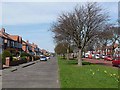
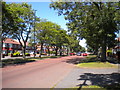
The Broadway, Marden
The service road alongside the Broadway, A193, has been signed as an advisory cycle route for south-north traffic between Tynemouth and Whitley Bay.
Image: © Oliver Dixon
Taken: 28 Mar 2012
0.09 miles
2
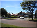
Link to service road from The Broadway, Cullercoats
Image: © Richard Vince
Taken: 28 Jun 2018
0.17 miles
4
Footpath along The Broadway, Cullercoats
Looking towards Whitley Bay.
Image: © Richard Vince
Taken: 28 Jun 2018
0.18 miles
5
The Broadway, Cullercoats
Looking towards Whitley Bay. While it appears to be a dual carriageway, the part of the road to the left of the trees is in fact a service road. There is no equivalent on this side of the road.
Image: © Richard Vince
Taken: 28 Jun 2018
0.18 miles
6
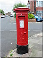
Post Box, Seacrest Avenue, Cullercoats
This box, which stands on the corner of Seacrest Avenue and Sandhurst Avenue, dates from the reign of King George VI (1936-1952) and can be distinguished from post boxes dating from the reign of King George V (1910-1936) by the more ornate cipher and the inclusion of the Roman Numeral VI.
Image: © Geoff Holland
Taken: 6 Jun 2023
0.19 miles
7
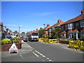
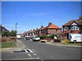
Sunlea Avenue, Cullercoats
Seen from Sandhurst Avenue.
Image: © Richard Vince
Taken: 28 Jun 2018
0.22 miles
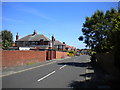
8
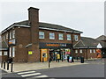
Sainsbury's Local, Broadway, Tynemouth
Sitting on the corner of Broadway and Beach Road and in a populated area, this shop serves the grocery needs of a large number of people. Built in the late 1950s, the building originally housed the Broadway Public House. It finally closed sometime during the first decade of the 21st century.
Image: © Geoff Holland
Taken: 6 Jun 2023
0.24 miles
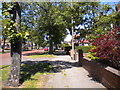
9
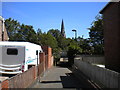
Footpath to Grand Parade, Cullercoats
From Links Road, heading under the Tyne & Wear Metro then past St George's Church (whose spire can be seen in the distance).
Image: © Richard Vince
Taken: 28 Jun 2018
0.24 miles
10
Wansbeck Avenue, Cullercoats
Seen from Sandhurst Avenue.
Image: © Richard Vince
Taken: 28 Jun 2018
0.25 miles