IMAGES TAKEN NEAR TO
Bolam Avenue, NORTH SHIELDS, NE30 3PX
Introduction
This page details the photographs taken nearby to Bolam Avenue, NE30 3PX by members of the Geograph project.
The Geograph project started in 2005 with the aim of publishing, organising and preserving representative images for every square kilometre of Great Britain, Ireland and the Isle of Man.

There are currently over 7.5m images from over14,400 individuals and you can help contribute to the project by visiting https://www.geograph.org.uk
Image Map (Loading...)


Getting Data...Please wait
Leaflet Map data © OpenStreetMap
Images are licensed for reuse under creativecommons.org/licenses/by-sa/2.0
Notes
- Clicking on the map will re-center to the selected point.
- The higher the marker number, the further away the image location is from the centre of the postcode.
Image Listing (9 Images Found)
Images are licensed for reuse under creativecommons.org/licenses/by-sa/2.0
Image
Details
Distance
2
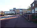
College Gates
The gates of Marden College
Image: © Weston Beggard
Taken: 13 Nov 2005
0.14 miles
3
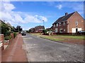
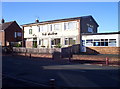
Houses and Shops
A block of shops, houses and flats in the middle of Marden estate.
Image: © Weston Beggard
Taken: 13 Nov 2005
0.14 miles
4
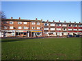
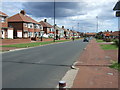
The Magpie
A modern 'Estate Pub' amongst houses in Marden.
Image: © Weston Beggard
Taken: 13 Nov 2005
0.14 miles

7
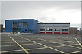
North Tyneside East fire station
North Tyneside East fire station, Preston North Road, North Shields, Tyne & Wear. Built on the site of the now demolished Image
Image: © Kevin Hale
Taken: 3 Aug 2010
0.24 miles
8
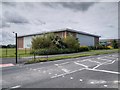
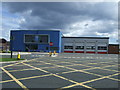
Sports Hall, John Spence Community High School
Image: © David Dixon
Taken: 21 Jun 2014
0.24 miles