IMAGES TAKEN NEAR TO
Farringdon Road, NORTH SHIELDS, NE30 3EY
Introduction
This page details the photographs taken nearby to Farringdon Road, NE30 3EY by members of the Geograph project.
The Geograph project started in 2005 with the aim of publishing, organising and preserving representative images for every square kilometre of Great Britain, Ireland and the Isle of Man.

There are currently over 7.5m images from over14,400 individuals and you can help contribute to the project by visiting https://www.geograph.org.uk
Image Map
Images are licensed for reuse under creativecommons.org/licenses/by-sa/2.0
Notes
- Clicking on the map will re-center to the selected point.
- The higher the marker number, the further away the image location is from the centre of the postcode.
Image Listing (2 Images Found)
Images are licensed for reuse under creativecommons.org/licenses/by-sa/2.0
Image
Details
Distance
1
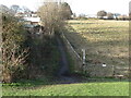
Public Footpath near Whitley Bay Ice Rink
This public footpath, which stands close to the site of the former Marden Well, leads to Hillheads Road adjacent to Whitley Bay Ice Rink. For a selection of detailed free to download walking routes in the area visit www.northtynesidewalks.co.uk
Image: © Geoff Holland
Taken: 30 Jan 2021
0.19 miles
2
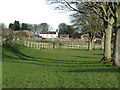
Open Space to rear of Marden House
Prior to April 1974 this stretch of green open space marked the boundary between Whitley Bay Borough Council and Tynemouth County Borough Council. In the distance is the rear of Marden House, a fine two storey house, close to Marden Quarry Park. This house was built, according to William Weaver Tomlinson in his 1893 book, 'Historical Notes on Cullercoats Whitley and Monkseaton', "by Mr. Thomas Taylor early in the century [19th]." The front of the house can be seen at https://www.geograph.org.uk/photo/6699306. For a selection of detailed free to download walking routes in the area visit www.northtynesidewalks.co.uk
Image: © Geoff Holland
Taken: 30 Jan 2021
0.22 miles