IMAGES TAKEN NEAR TO
Park Avenue, NORTH SHIELDS, NE30 2EU
Introduction
This page details the photographs taken nearby to Park Avenue, NE30 2EU by members of the Geograph project.
The Geograph project started in 2005 with the aim of publishing, organising and preserving representative images for every square kilometre of Great Britain, Ireland and the Isle of Man.

There are currently over 7.5m images from over14,400 individuals and you can help contribute to the project by visiting https://www.geograph.org.uk
Image Map
Images are licensed for reuse under creativecommons.org/licenses/by-sa/2.0
Notes
- Clicking on the map will re-center to the selected point.
- The higher the marker number, the further away the image location is from the centre of the postcode.
Image Listing (41 Images Found)
Images are licensed for reuse under creativecommons.org/licenses/by-sa/2.0
Image
Details
Distance
1
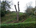
Dead tree in the park
A dead tree in Northumberland Park in Tynemouth, made into a feature.
Image: © Robert Graham
Taken: 14 Nov 2022
0.05 miles
2
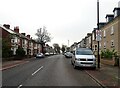
Washington Terrace
A street in the northern suburbs of North Shields. Early 20th century terraced housing of a superior style.
Image: © Robert Graham
Taken: 14 Nov 2022
0.05 miles
3
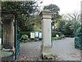
Gateposts at Northumberland Park
The north entrance to the park in North Shields on King Edward Road.
Image: © Robert Graham
Taken: 14 Nov 2022
0.06 miles
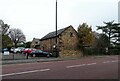
4
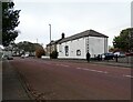
Tynemouth Golf Club Shop
On King Edward Road actually in North Shields. The golf course was created just before WWI and opened in 1914. The land was previously Spital Dene Farm, and the old farm buildings became the club house. With the building of a new clubhouse in 1940, the previous one became the club shop. This building is clearly an old farmhouse with attached byre and barn.
Image: © Robert Graham
Taken: 14 Nov 2022
0.07 miles
5
Former farm buildings at North Shields
These old stone buildings are now used by Tynemouth Golf Club but were once part of Spital Dene Farm. The farm was taken over and became Tynemouth Golf Course in 1914. The building in the centre was probably a byre with hayloft over.
Image: © Robert Graham
Taken: 14 Nov 2022
0.07 miles
6
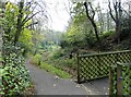
Path in Northumberland Park
Footpath beside a little ravine with a rustic footbridge. The park is Victorian, opened in 1885.
Image: © Robert Graham
Taken: 14 Nov 2022
0.07 miles
7
Golf Club Clubhouse
For Tynemouth Golf Club. The course was built on farmland in 1914 and used the old farm buildings for club premises. In 1940, this new club house was opened on Preston Avenue in North Shields.
Image: © Robert Graham
Taken: 14 Nov 2022
0.10 miles
8
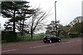
Road beside the golf course
King Edward Terrace alongside Tynemouth Golf Course. The road gets its name from King Edward's Bay at Tynemouth Headland. The king in question was probably Edward I who visited here several times during his wars in Scotland.
Image: © Robert Graham
Taken: 14 Nov 2022
0.10 miles
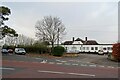
9
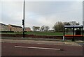
Bus shelter on Linskill Terrace
Suburban road in North Shields. The building on the left is a block of sheltered accommodation flats.
Image: © Robert Graham
Taken: 14 Nov 2022
0.11 miles
10
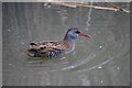
Water Rail in Northumberland Park, North Shields
Image: © Les Hull
Taken: 29 Jan 2021
0.11 miles