IMAGES TAKEN NEAR TO
East George Street, NORTH SHIELDS, NE30 1DY
Introduction
This page details the photographs taken nearby to East George Street, NE30 1DY by members of the Geograph project.
The Geograph project started in 2005 with the aim of publishing, organising and preserving representative images for every square kilometre of Great Britain, Ireland and the Isle of Man.

There are currently over 7.5m images from over14,400 individuals and you can help contribute to the project by visiting https://www.geograph.org.uk
Image Map
Images are licensed for reuse under creativecommons.org/licenses/by-sa/2.0
Notes
- Clicking on the map will re-center to the selected point.
- The higher the marker number, the further away the image location is from the centre of the postcode.
Image Listing (116 Images Found)
Images are licensed for reuse under creativecommons.org/licenses/by-sa/2.0
Image
Details
Distance
1
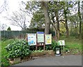
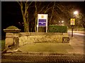
Notice board at Northumberland Park
On the boundary between North Shields and Tynemouth is this park which was opened in 1885. This is at the park entrance on Tynemouth Road.
Image: © Robert Graham
Taken: 14 Nov 2022
0.08 miles
2
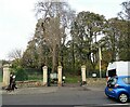
Entrance to Northumberland Park
On the boundary between Tynemouth and North Shields. This is the southern entrance on Tynemouth Road.
Image: © Robert Graham
Taken: 14 Nov 2022
0.08 miles
3
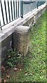
Old Milestone, A193, Tynemouth Road (East Side)
The milestone is located 20m east of the park entrance gate (Northumberland Park), behind the park wall and railings on the north side of the road. Parish of Tynemouth (North Tyneside District). Carved stone post, Newcastle number stone design, erected by the North Shields & Newcastle upon Tyne Turnpike trust in the 19th century.
Inscription reads (hidden by wall):
8
Grade II listed. List Entry Number: 1421393 https://historicengland.org.uk/listing/the-list/list-entry/1421393
Milestone Society National ID: NB_NCNS08
Image: © Colin Richardson
Taken: 26 Sep 2022
0.09 miles
4
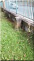
Old Milestone, A193, Tynemouth Road (West Side)
The milestone is located 20m east of the park entrance gate (Northumberland Park), behind the park wall and railings on the north side of the road. Parish of Tynemouth (North Tyneside District). Carved stone post, Newcastle number stone design, erected by the North Shields & Newcastle upon Tyne Turnpike trust in the 19th century.
Inscription reads (hidden by wall):
8
Grade II listed. List Entry Number: 1421393 https://historicengland.org.uk/listing/the-list/list-entry/1421393
Milestone Society National ID: NB_NCNS08
Image: © Colin Richardson
Taken: 21 Sep 2022
0.09 miles
5
Sign at Northumberland Park
Small park in North Shields.
Image: © Stephen Sweeney
Taken: 14 Jan 2009
0.10 miles
6

Pow Dene Court, North Shields
Business premises of Spivey's, 'The Crab Man', a shellfish wholesaler.
Image: © Andrew Curtis
Taken: 28 Jul 2013
0.11 miles
8
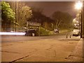
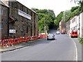
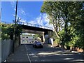
Tynemouth Road
Between Tynemouth and North Shields.
Image: © Stephen Sweeney
Taken: 14 Jan 2009
0.12 miles