IMAGES TAKEN NEAR TO
Preston North Road, NORTH SHIELDS, NE29 9PY
Introduction
This page details the photographs taken nearby to Preston North Road, NE29 9PY by members of the Geograph project.
The Geograph project started in 2005 with the aim of publishing, organising and preserving representative images for every square kilometre of Great Britain, Ireland and the Isle of Man.

There are currently over 7.5m images from over14,400 individuals and you can help contribute to the project by visiting https://www.geograph.org.uk
Image Map
Images are licensed for reuse under creativecommons.org/licenses/by-sa/2.0
Notes
- Clicking on the map will re-center to the selected point.
- The higher the marker number, the further away the image location is from the centre of the postcode.
Image Listing (16 Images Found)
Images are licensed for reuse under creativecommons.org/licenses/by-sa/2.0
Image
Details
Distance
1
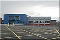
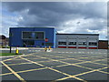
North Tyneside East fire station
North Tyneside East fire station, Preston North Road, North Shields, Tyne & Wear. Built on the site of the now demolished Image
Image: © Kevin Hale
Taken: 3 Aug 2010
0.04 miles
4
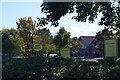
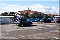
Trees and signs at Morrison's Tynemouth
This is the view from the petrol station which is screened off by trees.
Image: © Bill Boaden
Taken: 18 Sep 2011
0.07 miles
5
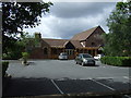
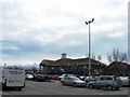
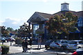
The Magic Lantern pub
On Preston Road North.
Image: © JThomas
Taken: 3 Aug 2013
0.12 miles
6
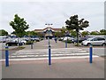
Morrison's Supermarket, Collingwood Centre
Image: © David Dixon
Taken: 21 Jun 2014
0.12 miles
7
Morrison's Tynemouth
There is another smaller Morrison's only about a mile away towards Whitley Bay.
Image: © Bill Boaden
Taken: 18 Sep 2011
0.12 miles