IMAGES TAKEN NEAR TO
Preston Towers, Preston Road, NORTH SHIELDS, NE29 9JU
Introduction
This page details the photographs taken nearby to Preston Towers, Preston Road, NE29 9JU by members of the Geograph project.
The Geograph project started in 2005 with the aim of publishing, organising and preserving representative images for every square kilometre of Great Britain, Ireland and the Isle of Man.

There are currently over 7.5m images from over14,400 individuals and you can help contribute to the project by visiting https://www.geograph.org.uk
Image Map
Images are licensed for reuse under creativecommons.org/licenses/by-sa/2.0
Notes
- Clicking on the map will re-center to the selected point.
- The higher the marker number, the further away the image location is from the centre of the postcode.
Image Listing (14 Images Found)
Images are licensed for reuse under creativecommons.org/licenses/by-sa/2.0
Image
Details
Distance
1
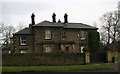
The Old Vicarage, Tynemouth/North Shields
Near Tynemouth Golf Course - but no sign of the new vicarage, or even a church! Perhaps this was the vicarage for Christ Church North Shields, about half a mile away.
Image: © Alan Fearon
Taken: 15 Dec 2005
0.12 miles
2
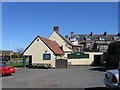
The Spread Eagle, Preston Village
A Public House
Image: © Alex McGregor
Taken: 12 Apr 2010
0.14 miles
4
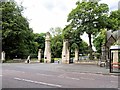
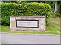
Preston Cemetery Gates, Walton Road
Preston Cemetery was built in the middle of the nineteenth century on 33 acres of land purchased from the grounds of Preston Villa. It was New Year’s Day 1857 and consecrated by the Bishop of Durham on April 23rd 1857 (http://www.prestontownship.org.uk/preston_cemetery Preston Township).
Image: © David Dixon
Taken: 21 Jun 2014
0.19 miles
6
Preston Cemetery and Tynemouth Crematorium
Preston Cemetery was built in the middle of the nineteenth century on 33 acres of land purchased from the grounds of Preston Villa. It was New Year’s Day 1857 and consecrated by the Bishop of Durham on April 23rd 1857 (http://www.prestontownship.org.uk/preston_cemetery Preston Township).
Image: © David Dixon
Taken: 21 Jun 2014
0.20 miles
7
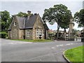
Lodge, Preston Cemetery
Preston Cemetery was built in the middle of the nineteenth century on 33 acres of land purchased from the grounds of Preston Villa. It was New Year’s Day 1857 and consecrated by the Bishop of Durham on April 23rd 1857 (http://www.prestontownship.org.uk/preston_cemetery Preston Township).
Image: © David Dixon
Taken: 21 Jun 2014
0.20 miles
8
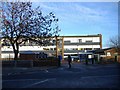
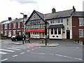
John Spence Community High School.
Opened in the late 1950's as 'Tynemouth Technical School.
Image: © Roger Cornfoot
Taken: 16 Dec 2006
0.21 miles
9
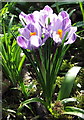
Purple Crocus
Snowdrops and then crocuses flower freely in the cemetery
Image: © Christine Westerback
Taken: 11 Mar 2012
0.21 miles
10
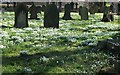
Preston Cemetery
A carpet of snowdrops form a blanket covering over the old grave sites.
Image: © Christine Westerback
Taken: 13 Mar 2010
0.22 miles