IMAGES TAKEN NEAR TO
Coldstream Way, NORTH SHIELDS, NE29 8DE
Introduction
This page details the photographs taken nearby to Coldstream Way, NE29 8DE by members of the Geograph project.
The Geograph project started in 2005 with the aim of publishing, organising and preserving representative images for every square kilometre of Great Britain, Ireland and the Isle of Man.

There are currently over 7.5m images from over14,400 individuals and you can help contribute to the project by visiting https://www.geograph.org.uk
Image Map
Images are licensed for reuse under creativecommons.org/licenses/by-sa/2.0
Notes
- Clicking on the map will re-center to the selected point.
- The higher the marker number, the further away the image location is from the centre of the postcode.
Image Listing (11 Images Found)
Images are licensed for reuse under creativecommons.org/licenses/by-sa/2.0
Image
Details
Distance
1
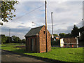
Mystery building
This small windowless building stands on a grass verge between Billy Mill Lane (in the background) and Barnstaple Road (in the foreground). It is fitted with a television-type aerial, and has a telegraph pole close to it, with a number of wires going off in various directions. I thought it may be a telephone exchange, but I am advised that this is unlikely. It would seem more probable that it has some purpose connected with the nearby underground reservoirs. Further suggestions gratefully received!
Update, Jan. 2021: I have received a message from a gentleman who lived locally to this little building. He tells me that he was taken into it on a school visit in the 1960s as a pupil at a nearby school. He says, "The building certainly has to do with the nearby reservoirs - or did have. It was full of meters and dials and those moving pen things that scratch lines on moving graph paper! All to do with the flowing of water at the nearby reservoirs - which I believe are now redundant as housing is being built over them!"
Apparently younger children called it "the fairies' house".
Image: © Richard Dorrell
Taken: 2 Aug 2011
0.10 miles
2
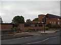
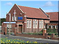
Quite a transformation!
Presumably built originally as a church, when this building was photographed by Bill Henderson in 2007, it was a Lighthouse Christian Centre (see Image). Today, with some alterations to the windows and doors, and doubtlessly to the interior, it serves as a local practice for Vets 4 Pets.
Image: © Richard Dorrell
Taken: 2 Aug 2011
0.13 miles
6
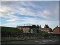
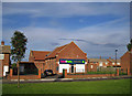
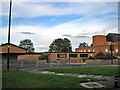
Building at Billy Mill reservoir
The reservoirs here are underground. The building pictured is in Whitehouse Lane, and is dated 1901.
Image: © Richard Dorrell
Taken: 2 Aug 2011
0.19 miles
7
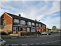
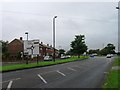
Shops in St Anselm Road, North Shields
Inferno (on the left) is a tanning parlour and beauty salon. After a session there, you can visit Canatrice the baker next door, or if in a hurry, pop into Bev's Light Bites next to the baker. The other two units are a One Stop convenience store and Oasis Hair Design studio.
Image: © Richard Dorrell
Taken: 2 Aug 2011
0.20 miles
8
St Aidan's Church, Billy Mill
Located on the B1316, Billy Mill Lane, and with a church hall alongside. The church is in the parish of St. George, Cullercoats.
Image: © Richard Dorrell
Taken: 2 Aug 2011
0.20 miles