IMAGES TAKEN NEAR TO
Alnmouth Avenue, NORTH SHIELDS, NE29 7BB
Introduction
This page details the photographs taken nearby to Alnmouth Avenue, NE29 7BB by members of the Geograph project.
The Geograph project started in 2005 with the aim of publishing, organising and preserving representative images for every square kilometre of Great Britain, Ireland and the Isle of Man.

There are currently over 7.5m images from over14,400 individuals and you can help contribute to the project by visiting https://www.geograph.org.uk
Image Map (Loading...)


Getting Data...Please wait
Leaflet Map data © OpenStreetMap
Images are licensed for reuse under creativecommons.org/licenses/by-sa/2.0
Notes
- Clicking on the map will re-center to the selected point.
- The higher the marker number, the further away the image location is from the centre of the postcode.
Image Listing (5 Images Found)
Images are licensed for reuse under creativecommons.org/licenses/by-sa/2.0
Image
Details
Distance
1

St Joseph's R.C. Church, Wallsend Road
Image: © Bill Henderson
Taken: 11 Jun 2012
0.11 miles
2
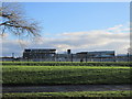
The Norham High School
Taken from Norham Road.
Image: © Ian S
Taken: 2 Feb 2013
0.14 miles
3
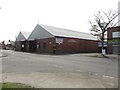
Bus Depot, Percy Main
A large site on Norham Road operated as a bus depot by Go North East.
Image: © Graham Robson
Taken: 1 May 2017
0.19 miles
4
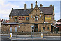
The Redburn
The Redburn public house in Percy Main.
Image: © Peter McDermott
Taken: 21 May 2011
0.20 miles
5
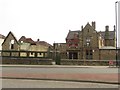
Public House, Percy Main
The Redburn is a public house in Percy Main.
Image: © Graham Robson
Taken: 1 May 2017
0.20 miles