IMAGES TAKEN NEAR TO
Albion Road, NORTH SHIELDS, NE29 0HA
Introduction
This page details the photographs taken nearby to Albion Road, NE29 0HA by members of the Geograph project.
The Geograph project started in 2005 with the aim of publishing, organising and preserving representative images for every square kilometre of Great Britain, Ireland and the Isle of Man.

There are currently over 7.5m images from over14,400 individuals and you can help contribute to the project by visiting https://www.geograph.org.uk
Image Map (Loading...)


Getting Data...Please wait
Leaflet Map data © OpenStreetMap
Images are licensed for reuse under creativecommons.org/licenses/by-sa/2.0
Notes
- Clicking on the map will re-center to the selected point.
- The higher the marker number, the further away the image location is from the centre of the postcode.
Image Listing (90 Images Found)
Images are licensed for reuse under creativecommons.org/licenses/by-sa/2.0
Image
Details
Distance
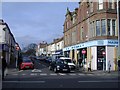
1

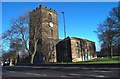
Jubilee Corner, Albion Road, North Shields
This was the site of the former Royal Jubilee School which was founded in 1810, and continued to educate local children until 1935. This memorial commemorates Tynemouth-born Thomas Haswell, Headmaster of the school between 1839 and 1886, under whose guidance, "the school became renowned for its innovation, learning and care for its pupils". A nearby street, Haswell Gardens, was also named after him. For a selection of detailed free to download walking routes in the area visit www.northtynesidewalks.co.uk
Image: © Geoff Holland
Taken: 16 Feb 2021
0.02 miles
3
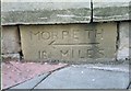
Old Milestone by the A193, Albion Road in North Shields
Carved stone plaque by the A193, in parish of Tynemouth (North Tyneside District), North Shields, Albion Road, by Christ Church churchyard entrance, back of footpath, built into stone churchyard wall at corner, on North side of road. Erected by the Shields & Morpeth & Branches turnpike trust in the 19th century.
Inscription reads:-
MORPETH
{<-arrow}
16½ MILES
The piers and walls of Christ Church are Grade II listed.
List Entry Number: 1355012 https://historicengland.org.uk/listing/the-list/list-entry/1355012
Milestone Society National ID: NB_MPNS16
Image: © IA Davison
Taken: 24 Jul 2004
0.04 miles
4
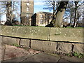
Old Milestone, Christ Church, North Shields
Built into the stone churchyard wall, this carved stone plaque stands alongside the A193 close to the churchyard entrance. It was erected in the 19th century. In the background is Christ Church. For a selection of detailed free to download walking routes in the area visit www.northtynesidewalks.co.uk
Image: © Geoff Holland
Taken: 16 Feb 2021
0.04 miles
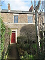
5
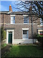
6 Spring Terrace, North Shields
Built circa 1830, this two storey dwelling is a Grade II Listed building. For a selection of detailed free to download walking routes in the area visit www.northtynesidewalks.co.uk
Image: © Geoff Holland
Taken: 16 Feb 2021
0.05 miles
7
7 Spring Terrace, North Shields
Built circa 1830, this two storey dwelling is a Grade II Listed building. For a selection of detailed free to download walking routes in the area visit www.northtynesidewalks.co.uk
Image: © Geoff Holland
Taken: 16 Feb 2021
0.06 miles
8
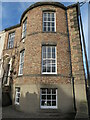
5 Northumberland Place, North Shields
This fine building is part of a terrace of five properties (1-5 Northumberland Place) all of which are Grade II Listed. The terrace was built circa 1811 with the properties 1 & 5 both possessing elegant bow windows, a feature which is echoed in the neighbouring 12 & 20 Northumberland Square. For a selection of detailed free to download walking routes in the area visit www.northtynesidewalks.co.uk
Image: © Geoff Holland
Taken: 16 Feb 2021
0.07 miles
9

Upper Camden Street, North Shields
The tower of Christ Church is visible at the end of the road.
Image: © Andrew Curtis
Taken: 28 Jul 2013
0.07 miles
10
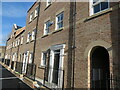
Northumberland Close, North Shields
These luxury new-build townhouses are situated on Northumberland Close, North Shields and form part of the prestigious Northumberland Square development. They lie between Northumberland Square and Albion Road on a street formerly known as Upper Camden Street. For a selection of detailed free to download walking routes in the area visit www.northtynesidewalks.co.uk
Image: © Geoff Holland
Taken: 16 Feb 2021
0.07 miles