IMAGES TAKEN NEAR TO
Bellshill Close, WALLSEND, NE28 9XJ
Introduction
This page details the photographs taken nearby to Bellshill Close, NE28 9XJ by members of the Geograph project.
The Geograph project started in 2005 with the aim of publishing, organising and preserving representative images for every square kilometre of Great Britain, Ireland and the Isle of Man.

There are currently over 7.5m images from over14,400 individuals and you can help contribute to the project by visiting https://www.geograph.org.uk
Image Map (Loading...)


Getting Data...Please wait
Leaflet Map data © OpenStreetMap
Images are licensed for reuse under creativecommons.org/licenses/by-sa/2.0
Notes
- Clicking on the map will re-center to the selected point.
- The higher the marker number, the further away the image location is from the centre of the postcode.
Image Listing (20 Images Found)
Images are licensed for reuse under creativecommons.org/licenses/by-sa/2.0
Image
Details
Distance
1
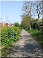
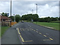
Waggonway
One of the many waggonways that criss cross this area. Former mineral lines, these waggonways have been upgrades to both footpaths and bridleway
Image: © Christine Westerback
Taken: 20 May 2012
0.15 miles
2
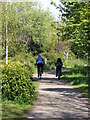
Waggonway
Cyclist heading East
Image: © Christine Westerback
Taken: 20 May 2012
0.15 miles
3
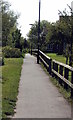
Waggonway Path
This path runs parallel to the waggonway, looking West
Image: © Christine Westerback
Taken: 20 May 2012
0.15 miles
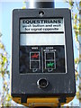
9
Equestrian Crossing
What happens if you're riding a Shetland pony?
Image: © Christine Westerback
Taken: 20 May 2012
0.21 miles