IMAGES TAKEN NEAR TO
Bellshill Close, WALLSEND, NE28 9XD
Introduction
This page details the photographs taken nearby to Bellshill Close, NE28 9XD by members of the Geograph project.
The Geograph project started in 2005 with the aim of publishing, organising and preserving representative images for every square kilometre of Great Britain, Ireland and the Isle of Man.

There are currently over 7.5m images from over14,400 individuals and you can help contribute to the project by visiting https://www.geograph.org.uk
Image Map (Loading...)


Getting Data...Please wait
Leaflet Map data © OpenStreetMap
Images are licensed for reuse under creativecommons.org/licenses/by-sa/2.0
Notes
- Clicking on the map will re-center to the selected point.
- The higher the marker number, the further away the image location is from the centre of the postcode.
Image Listing (11 Images Found)
Images are licensed for reuse under creativecommons.org/licenses/by-sa/2.0
Image
Details
Distance
10
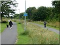
The Black Path
One of the numerous waggonways in North Tyneside which once served the coalmines of the area and have now been converted into a series of footpaths and bridleways. Here two parallel paths have been developed - to the left a tarmac path for cyclists, to the right a cinder path for horse riders. Not that the cyclist in view seems to take note of the distinction.
Image: © Oliver Dixon
Taken: 6 Jul 2023
0.24 miles