IMAGES TAKEN NEAR TO
Bathgate Close, WALLSEND, NE28 9SY
Introduction
This page details the photographs taken nearby to Bathgate Close, NE28 9SY by members of the Geograph project.
The Geograph project started in 2005 with the aim of publishing, organising and preserving representative images for every square kilometre of Great Britain, Ireland and the Isle of Man.

There are currently over 7.5m images from over14,400 individuals and you can help contribute to the project by visiting https://www.geograph.org.uk
Image Map
Images are licensed for reuse under creativecommons.org/licenses/by-sa/2.0
Notes
- Clicking on the map will re-center to the selected point.
- The higher the marker number, the further away the image location is from the centre of the postcode.
Image Listing (14 Images Found)
Images are licensed for reuse under creativecommons.org/licenses/by-sa/2.0
Image
Details
Distance
1
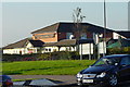
The Jolly Bowman
This pub has absolutely nothing to do with archery. The name is the result of a naming competition. "Bowman" is a play on the "Beaumont" which was one of the main coal seams in the area.
Image: © Mac McCarron
Taken: 20 Oct 2007
0.03 miles
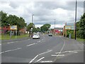
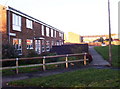
4
Signpost
This road divides two parts of the same waggonway
Image: © Christine Westerback
Taken: 20 May 2012
0.07 miles
5
Battle Hill
Modern housing stock which makes up the huge Battle Hill housing estate.
Image: © Weston Beggard
Taken: 13 Nov 2005
0.10 miles
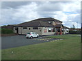
6
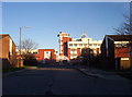
North Tyneside College
The entrance to North Tyneside College, which has expanded considerably since the photographer attended many years ago. The design of the main building is supposed to be redolent of a ship - maybe it is if you squint.
Image: © Weston Beggard
Taken: 13 Nov 2005
0.10 miles
7
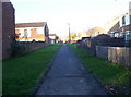
Footpath
One of the pedestrian-only paths that criss-cross Battle Hill estate.
Image: © Weston Beggard
Taken: 13 Nov 2005
0.10 miles
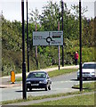
8
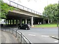
Roundabout under the Coast Road at Willington Square
Image: © Oliver Dixon
Taken: 6 Jul 2023
0.13 miles
9
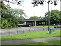
Grade-separated junction at Willington Square
The Coast Road crosses the viaduct over the roundabout on Churchill Street/Battle Hill Drive.
Image: © Oliver Dixon
Taken: 6 Jul 2023
0.14 miles
10
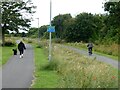
The Black Path
One of the numerous waggonways in North Tyneside which once served the coalmines of the area and have now been converted into a series of footpaths and bridleways. Here two parallel paths have been developed - to the left a tarmac path for cyclists, to the right a cinder path for horse riders. Not that the cyclist in view seems to take note of the distinction.
Image: © Oliver Dixon
Taken: 6 Jul 2023
0.15 miles