IMAGES TAKEN NEAR TO
Kings Road North, WALLSEND, NE28 9JJ
Introduction
This page details the photographs taken nearby to Kings Road North, NE28 9JJ by members of the Geograph project.
The Geograph project started in 2005 with the aim of publishing, organising and preserving representative images for every square kilometre of Great Britain, Ireland and the Isle of Man.

There are currently over 7.5m images from over14,400 individuals and you can help contribute to the project by visiting https://www.geograph.org.uk
Image Map (Loading...)


Getting Data...Please wait
Leaflet Map data © OpenStreetMap
Images are licensed for reuse under creativecommons.org/licenses/by-sa/2.0
Notes
- Clicking on the map will re-center to the selected point.
- The higher the marker number, the further away the image location is from the centre of the postcode.
Image Listing (8 Images Found)
Images are licensed for reuse under creativecommons.org/licenses/by-sa/2.0
Image
Details
Distance
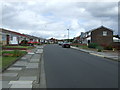
2
Rising Sun Cottages, Wallsend
A long terrace of houses on the southern boundary of Rising Sun Country Park.
Image: © Graham Robson
Taken: 19 Feb 2017
0.09 miles
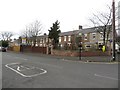
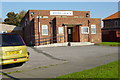
3
School under construction
The original school, which wasn't very old, was the victim of an arson attack.
Image: © Mac McCarron
Taken: 15 Oct 2007
0.22 miles
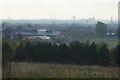
5
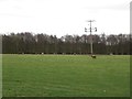
Grass field, Rising Sun Farm
A grass field being grazed by sheep close to the building of Rising Sun Farm.
Image: © Graham Robson
Taken: 19 Feb 2017
0.23 miles
6
Irvine Hodgson Memorial Baptist Church
Image: © Mac McCarron
Taken: 21 Oct 2007
0.24 miles
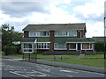
8
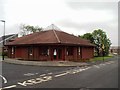
The Church of the Good Shepherd, Battle Hill, Wallsend
Image: © Bill Henderson
Taken: 10 Jun 2012
0.25 miles