IMAGES TAKEN NEAR TO
Blandford Way, WALLSEND, NE28 9BX
Introduction
This page details the photographs taken nearby to Blandford Way, NE28 9BX by members of the Geograph project.
The Geograph project started in 2005 with the aim of publishing, organising and preserving representative images for every square kilometre of Great Britain, Ireland and the Isle of Man.

There are currently over 7.5m images from over14,400 individuals and you can help contribute to the project by visiting https://www.geograph.org.uk
Image Map (7 Images)


Getting Data...Please wait
Leaflet Map data © OpenStreetMap
Images are licensed for reuse under creativecommons.org/licenses/by-sa/2.0
Notes
- Clicking on the map will re-center to the selected point.
- The higher the marker number, the further away the image location is from the centre of the postcode.
Image Listing (7 Images Found)
Images are licensed for reuse under creativecommons.org/licenses/by-sa/2.0
Image
Details
Distance
3
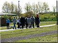
Revellers on a Sunny Day
The sun brought people out and this group, glasses of wine and beer in hand, walked along the waggonway, perhaps on their way to a BBQ.
Image: © Christine Westerback
Taken: 20 May 2012
0.13 miles
4
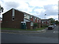
Coast Way Shopping Centre
On Battle Hill Drive.
Image: © Gerald England
Taken: 19 Oct 2022
0.16 miles
5
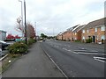
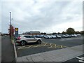
Battle Hill Drive
Near the Coast Way Shopping Centre.
Image: © Gerald England
Taken: 19 Oct 2022
0.18 miles
6
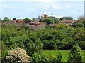
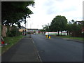
Zoomed Photograph of Tynemouth Metropolitan College, Wallsend
Taken from Rising Sun Hill
Image: © Christine Westerback
Taken: 4 Jun 2012
0.19 miles
7

Awful warning
What happens to motor bikes being ridden on the Black Path, a waggonway in Willington. 27 seized in the "last" year - but which year was that?
Image: © Oliver Dixon
Taken: 6 Jul 2023
0.22 miles