IMAGES TAKEN NEAR TO
Beckford Close, WALLSEND, NE28 9AY
Introduction
This page details the photographs taken nearby to Beckford Close, NE28 9AY by members of the Geograph project.
The Geograph project started in 2005 with the aim of publishing, organising and preserving representative images for every square kilometre of Great Britain, Ireland and the Isle of Man.

There are currently over 7.5m images from over14,400 individuals and you can help contribute to the project by visiting https://www.geograph.org.uk
Image Map (Loading...)


Getting Data...Please wait
Leaflet Map data © OpenStreetMap
Images are licensed for reuse under creativecommons.org/licenses/by-sa/2.0
Notes
- Clicking on the map will re-center to the selected point.
- The higher the marker number, the further away the image location is from the centre of the postcode.
Image Listing (10 Images Found)
Images are licensed for reuse under creativecommons.org/licenses/by-sa/2.0
Image
Details
Distance
3
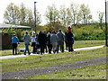
Revellers on a Sunny Day
The sun brought people out and this group, glasses of wine and beer in hand, walked along the waggonway, perhaps on their way to a BBQ.
Image: © Christine Westerback
Taken: 20 May 2012
0.22 miles
4
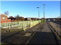
Subway under the Coast Road
One of the few spots where it is possible to cross the busy dual carriageway Coast Road in safety. The cycle track continues along the north side of the road.
Image: © Oliver Dixon
Taken: 4 Dec 2013
0.23 miles
5
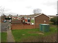
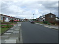
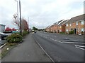
Houses, Balidon Close, Wallsend
Part of a large housing estate. Seen from the footpath which runs alongside the A1058.
Image: © Graham Robson
Taken: 19 Feb 2017
0.23 miles
6
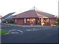
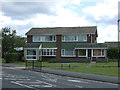
Good Shepherd Church at Battle Hill, Wallsend
A modern church and presbytery on Battle Hill estate. It's called The Church of The Good Shepherd. Founded in 1983, it is a joint Anglican, Methodist and URC Local Ecumenical Project, and has Sunday services at 9.30 and 6.00.
Image: © Weston Beggard
Taken: 13 Nov 2005
0.24 miles
7
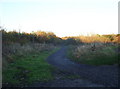
Footpath
Footpath leading to Rising Sun Farm on the very northern edge of Battle Hill estate.
Image: © Weston Beggard
Taken: 13 Nov 2005
0.24 miles
8
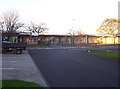
Battle Hill Primary School
A large, modern school on Battle Hill estate.
Image: © Weston Beggard
Taken: 13 Nov 2005
0.24 miles
9
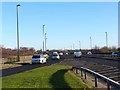
Battle Hill Drive
Near the Coast Way Shopping Centre.
Image: © Gerald England
Taken: 19 Oct 2022
0.24 miles
10
Slip road onto the Coast Road
The busy dual carriageway Coast Road carries traffic from Newcastle to Tynemouth. The cycle path which runs along the north side of the road here has to cross a sliproad.
Image: © Oliver Dixon
Taken: 4 Dec 2013
0.24 miles