IMAGES TAKEN NEAR TO
Ribblesdale, WALLSEND, NE28 8UA
Introduction
This page details the photographs taken nearby to Ribblesdale, NE28 8UA by members of the Geograph project.
The Geograph project started in 2005 with the aim of publishing, organising and preserving representative images for every square kilometre of Great Britain, Ireland and the Isle of Man.

There are currently over 7.5m images from over14,400 individuals and you can help contribute to the project by visiting https://www.geograph.org.uk
Image Map (Loading...)


Getting Data...Please wait
Leaflet Map data © OpenStreetMap
Images are licensed for reuse under creativecommons.org/licenses/by-sa/2.0
Notes
- Clicking on the map will re-center to the selected point.
- The higher the marker number, the further away the image location is from the centre of the postcode.
Image Listing (10 Images Found)
Images are licensed for reuse under creativecommons.org/licenses/by-sa/2.0
Image
Details
Distance
1
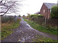
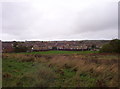
Footpath
Footpath between housing on the right and allotment gardens on the left
Image: © Weston Beggard
Taken: 22 Oct 2005
0.18 miles
2
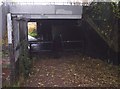
Railway bridge
Footpath under the main East-coast railway line, with a curious barrier that seems designed to prevent anyone overweight from passing through.....
Image: © Weston Beggard
Taken: 22 Oct 2005
0.18 miles
3
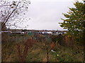
Allotment gardens
Allotment gardens to the north of the A1058 Coast Road
Image: © Weston Beggard
Taken: 22 Oct 2005
0.18 miles
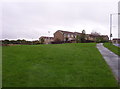
4
Wiltshire Drive
Housing around Wiltshire Drive. The land in the foreground is the sad remains of a BMX bike track, where the photographer spent much of his early teenage years.
Image: © Weston Beggard
Taken: 22 Oct 2005
0.18 miles
5
Wiltshire Drive
Modern housing on Wiltshire Drive
Image: © Weston Beggard
Taken: 22 Oct 2005
0.18 miles
6
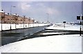
The 'Original' Coast Road
Taken near the transact lines of 2 grid squares. This view was taken from the corner of West St as it joined the A1058. The flats are now demolished and surprisingly nothing has been built in its place - yet!!
Image: © Christine Westerback
Taken: Unknown
0.18 miles
7
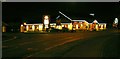
Powder Monkey
Not named after boys who carried powder in the Royal Navy but after boys who carried out a similar function in the coal mines (allegedly). Forty or fifty years ago it was used as the name of a small area to the west where the allotments are located.
Image: © Mac McCarron
Taken: 20 Oct 2007
0.21 miles
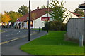
9
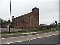
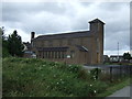
The R.C. Church of St Bernadette, Station Road, Wallsend
Image: © Bill Henderson
Taken: 11 Jun 2012
0.23 miles