IMAGES TAKEN NEAR TO
Swaledale, WALLSEND, NE28 8TR
Introduction
This page details the photographs taken nearby to Swaledale, NE28 8TR by members of the Geograph project.
The Geograph project started in 2005 with the aim of publishing, organising and preserving representative images for every square kilometre of Great Britain, Ireland and the Isle of Man.

There are currently over 7.5m images from over14,400 individuals and you can help contribute to the project by visiting https://www.geograph.org.uk
Image Map
Images are licensed for reuse under creativecommons.org/licenses/by-sa/2.0
Notes
- Clicking on the map will re-center to the selected point.
- The higher the marker number, the further away the image location is from the centre of the postcode.
Image Listing (10 Images Found)
Images are licensed for reuse under creativecommons.org/licenses/by-sa/2.0
Image
Details
Distance
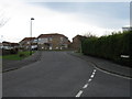
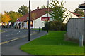
3
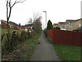
Pathway, Wallsend
Between Wiltshire Drive and East Benton Farm
Image: © Alex McGregor
Taken: 6 Apr 2010
0.11 miles
5
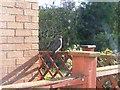
Sparrowhawk
A regular visitor along with his mate. Many residents put out food for small birds and the sparrowhawks are only too pleased to take advantage.
Image: © Mac McCarron
Taken: 18 Oct 2008
0.15 miles
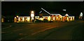
9
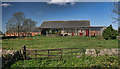
East Benton Farm
Buildings at East Benton Farm.
Image: © Peter McDermott
Taken: 2 May 2011
0.21 miles
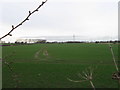
10
Powder Monkey
Not named after boys who carried powder in the Royal Navy but after boys who carried out a similar function in the coal mines (allegedly). Forty or fifty years ago it was used as the name of a small area to the west where the allotments are located.
Image: © Mac McCarron
Taken: 20 Oct 2007
0.23 miles