IMAGES TAKEN NEAR TO
Station Road, WALLSEND, NE28 8RG
Introduction
This page details the photographs taken nearby to Station Road, NE28 8RG by members of the Geograph project.
The Geograph project started in 2005 with the aim of publishing, organising and preserving representative images for every square kilometre of Great Britain, Ireland and the Isle of Man.

There are currently over 7.5m images from over14,400 individuals and you can help contribute to the project by visiting https://www.geograph.org.uk
Image Map (Loading...)


Getting Data...Please wait
Leaflet Map data © OpenStreetMap
Images are licensed for reuse under creativecommons.org/licenses/by-sa/2.0
Notes
- Clicking on the map will re-center to the selected point.
- The higher the marker number, the further away the image location is from the centre of the postcode.
Image Listing (65 Images Found)
Images are licensed for reuse under creativecommons.org/licenses/by-sa/2.0
Image
Details
Distance

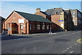
3
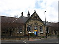
Richardson Dees Park
This building is at the entrance to the park and I think, is used for offices
Image: © Christine Westerback
Taken: 4 Mar 2011
0.07 miles
4
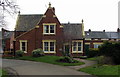
Entrance to Richardson Dees Park
Robert Richardson Dee (1856-1908) was a famous Wallsend figure. A solicitor and keen historian, he lived in Wallsend Hall which abuts the park. For more information http://www.john-s-stephenson.net/wallsend%20hall.htm
Image: © Christine Westerback
Taken: 4 Mar 2011
0.07 miles
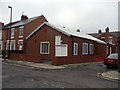
7
Trinity Methodist Church, Station Road, Wallsend
Image: © Bill Henderson
Taken: 10 Jun 2012
0.10 miles
8
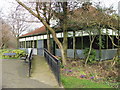
The Pavilion, Richardson Dees Park
I would guess this is used for those who play green bowls.
Image: © Christine Westerback
Taken: 4 Mar 2011
0.10 miles
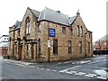
10
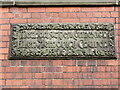
Stone Plaque, Allen Memorial Church, Park Road, Wallsend
The brick and stone built Allen Memorial Church https://www.geograph.org.uk/photo/6772871 was erected in 1903, as evidenced by the detailed stone plaque, by Howdon builder William Thomas Weir, one of the major contractors in the area at that time. He also built the Burn Closes Bridge, Wallsend Drill Hall and Tynemouth Conservative Club. The original spire was removed some years ago as it was unsafe and would have been too costly to replace. A stone plate on the west gable commemorates John Allen, one of the pioneers of the north-eastern Alkali trade. For a selection of detailed free to download walking routes in the area visit www.northtynesidewalks.co.uk
Image: © Geoff Holland
Taken: 9 Mar 2021
0.11 miles