IMAGES TAKEN NEAR TO
Woodbine Avenue, WALLSEND, NE28 8HE
Introduction
This page details the photographs taken nearby to Woodbine Avenue, NE28 8HE by members of the Geograph project.
The Geograph project started in 2005 with the aim of publishing, organising and preserving representative images for every square kilometre of Great Britain, Ireland and the Isle of Man.

There are currently over 7.5m images from over14,400 individuals and you can help contribute to the project by visiting https://www.geograph.org.uk
Image Map
Images are licensed for reuse under creativecommons.org/licenses/by-sa/2.0
Notes
- Clicking on the map will re-center to the selected point.
- The higher the marker number, the further away the image location is from the centre of the postcode.
Image Listing (100 Images Found)
Images are licensed for reuse under creativecommons.org/licenses/by-sa/2.0
Image
Details
Distance
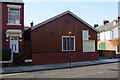
2
Trinity Methodist Church, Station Road, Wallsend
Image: © Bill Henderson
Taken: 10 Jun 2012
0.06 miles
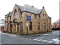
3
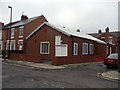
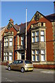
The Old Library - 1912
I remember 'Library day' at school when we our class would march to this building to choose a book. The children's section was downstairs and I can still recall the feeling I had when I browsed the books. It seemed like a wonderland. A new library opened which was modern and didn't give the same feeling. No longer a library, the building is used as an office to help people with learning disabilities.
Image: © Christine Westerback
Taken: 4 Mar 2011
0.07 miles
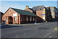
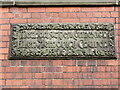
6
Stone Plaque, 205 Park Road, Wallsend
This large brick and stone building was originally erected by The Castner Kellner Alkali Co. for use by their workers, and was known as the Castner Memorial Institute. The company was formed in 1895 to manufacture caustic alkali and bleaching powder. The stone plaque above the door reveals that the building dates from 1912. For a selection of detailed free to download walking routes in the area visit www.northtynesidewalks.co.uk
Image: © Geoff Holland
Taken: 9 Mar 2021
0.07 miles
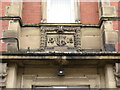
7
Stone Plaque, Allen Memorial Church, Park Road, Wallsend
The brick and stone built Allen Memorial Church https://www.geograph.org.uk/photo/6772871 was erected in 1903, as evidenced by the detailed stone plaque, by Howdon builder William Thomas Weir, one of the major contractors in the area at that time. He also built the Burn Closes Bridge, Wallsend Drill Hall and Tynemouth Conservative Club. The original spire was removed some years ago as it was unsafe and would have been too costly to replace. A stone plate on the west gable commemorates John Allen, one of the pioneers of the north-eastern Alkali trade. For a selection of detailed free to download walking routes in the area visit www.northtynesidewalks.co.uk
Image: © Geoff Holland
Taken: 9 Mar 2021
0.08 miles
8
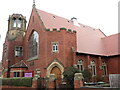
Allen Memorial Church, Park Road, Wallsend
This brick and stone built church was erected in 1903 by Howdon builder William Thomas Weir, one of the major contractors in the area at that time. He also built the Burn Closes Bridge, Wallsend Drill Hall and Tynemouth Conservative Club. The original spire was removed some years ago as it was unsafe and would have been too costly to replace. A stone plate on the west gable commemorates John Allen, one of the pioneers of the north-eastern Alkali trade. For a selection of detailed free to download walking routes in the area visit www.northtynesidewalks.co.uk
Image: © Geoff Holland
Taken: 9 Mar 2021
0.08 miles
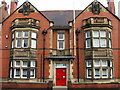
9
Ex Public Library, Park Road, Wallsend
Now used by Government.
Image: © Mac McCarron
Taken: 21 Oct 2007
0.08 miles
