IMAGES TAKEN NEAR TO
Thompson Gardens, WALLSEND, NE28 8DJ
Introduction
This page details the photographs taken nearby to Thompson Gardens, NE28 8DJ by members of the Geograph project.
The Geograph project started in 2005 with the aim of publishing, organising and preserving representative images for every square kilometre of Great Britain, Ireland and the Isle of Man.

There are currently over 7.5m images from over14,400 individuals and you can help contribute to the project by visiting https://www.geograph.org.uk
Image Map (Loading...)


Getting Data...Please wait
Leaflet Map data © OpenStreetMap
Images are licensed for reuse under creativecommons.org/licenses/by-sa/2.0
Notes
- Clicking on the map will re-center to the selected point.
- The higher the marker number, the further away the image location is from the centre of the postcode.
Image Listing (22 Images Found)
Images are licensed for reuse under creativecommons.org/licenses/by-sa/2.0
Image
Details
Distance
1
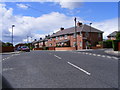
Junction of Prince Road and Queen's Crescent
Local authority housing of the 1920s.
Image: © Mac McCarron
Taken: 20 Jun 2008
0.04 miles
2
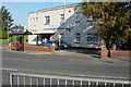
Wallsend Ex Service and CIU working Mens Club
Most people call it the Comrades
Image: © Mac McCarron
Taken: 21 Oct 2007
0.08 miles
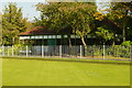
3
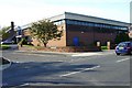
Wallsend Boys Club
Alan Shearer played football for this club
Image: © Mac McCarron
Taken: 21 Oct 2007
0.09 miles

6
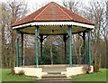
Bandstand
Richardson Dees Park, Wallsend
Image: © Christine Westerback
Taken: 4 Mar 2011
0.17 miles
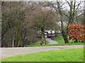
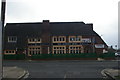
8

"Veteran's Hut" and Kiosk
The veterans have now moved to the pavilion.
Image: © Mac McCarron
Taken: 21 Oct 2007
0.18 miles
10
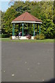
Bandstand, Richardson Dees Park, Wallsend
Image: © Mac McCarron
Taken: 21 Oct 2007
0.18 miles