IMAGES TAKEN NEAR TO
Richardson Street, WALLSEND, NE28 7PR
Introduction
This page details the photographs taken nearby to Richardson Street, NE28 7PR by members of the Geograph project.
The Geograph project started in 2005 with the aim of publishing, organising and preserving representative images for every square kilometre of Great Britain, Ireland and the Isle of Man.

There are currently over 7.5m images from over14,400 individuals and you can help contribute to the project by visiting https://www.geograph.org.uk
Image Map (Loading...)


Getting Data...Please wait
Leaflet Map data © OpenStreetMap
Images are licensed for reuse under creativecommons.org/licenses/by-sa/2.0
Notes
- Clicking on the map will re-center to the selected point.
- The higher the marker number, the further away the image location is from the centre of the postcode.
Image Listing (96 Images Found)
Images are licensed for reuse under creativecommons.org/licenses/by-sa/2.0
Image
Details
Distance
1
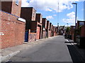
A Wallsend back-lane
This is the back-lane between Cumberland Street and Alnwick Street. The flat roofed extensions are bathrooms and toilets, these were added mainly during the 1960s and 1970s.
Image: © Mac McCarron
Taken: 20 Jun 2008
0.05 miles
2
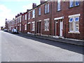
Cumberland Street, Wallsend
Typical of many streets of flats on Tyneside. The road surface is now tarmac but the original basalt cobbles lie beneath the surface. The flats were built in the early years of the 20th century.
Image: © Mac McCarron
Taken: 20 Jun 2008
0.07 miles
3
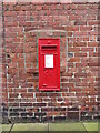
Post Box, Alnwick Street, Wallsend
Roadside wall boxes first appeared in 1857 as a cheaper alternative to pillar boxes, especially in rural areas. This box dates from the reign of King George V (1936-1952) and is located in the gable wall of a property which fronts onto Boyd Road. For a selection of detailed free to download walking routes in the area visit www.northtynesidewalks.co.uk
Image: © Geoff Holland
Taken: 9 Mar 2021
0.07 miles
4
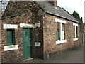
Derelict Bungalow
Empty and boarded up on Boyd Road
Image: © Christine Westerback
Taken: 16 Mar 2012
0.09 miles
5
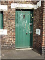
Front Door of Derelict Building
Image: © Christine Westerback
Taken: 16 Mar 2012
0.09 miles
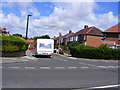
6

Boyd Crescent, Wallsend
These semi-detached houses at the west end of the crescent were built by the local authority during the 1950s.
Image: © Mac McCarron
Taken: 20 Jun 2008
0.10 miles
7
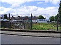
Allotments near the centre of Wallsend
Image: © Mac McCarron
Taken: 20 Jun 2008
0.10 miles
8
Boyd Crescent, Wallsend
These semi-detached houses were built in the 1930s.
Image: © Mac McCarron
Taken: 20 Jun 2008
0.10 miles
9

Pier Capping Stone, West Villa, The Green, Wallsend
The attractive semi-detached mid-Victorian house, West Villa, has recently been renovated, with many of its original external features retained, including this historic pier capping stone featuring the name of the house engraved into the façade. For a selection of detailed free to download walking routes in the area visit www.northtynesidewalks.co.uk
Image: © Geoff Holland
Taken: 9 Mar 2021
0.11 miles
10
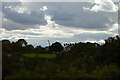
Boyd Road Wallsend from Holy Cross
Looking south over Wallsend Dene towards Boyd Road with a shipyard crane in the distance
Image: © Mac McCarron
Taken: 25 Sep 2007
0.11 miles