IMAGES TAKEN NEAR TO
The Green, WALLSEND, NE28 7PA
Introduction
This page details the photographs taken nearby to The Green, NE28 7PA by members of the Geograph project.
The Geograph project started in 2005 with the aim of publishing, organising and preserving representative images for every square kilometre of Great Britain, Ireland and the Isle of Man.

There are currently over 7.5m images from over14,400 individuals and you can help contribute to the project by visiting https://www.geograph.org.uk
Image Map (Loading...)


Getting Data...Please wait
Leaflet Map data © OpenStreetMap
Images are licensed for reuse under creativecommons.org/licenses/by-sa/2.0
Notes
- Clicking on the map will re-center to the selected point.
- The higher the marker number, the further away the image location is from the centre of the postcode.
Image Listing (86 Images Found)
Images are licensed for reuse under creativecommons.org/licenses/by-sa/2.0
Image
Details
Distance
1
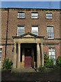
Doorway, Wallsend Hall, Wallsend
Built in the early 19th century, the buildings and grounds of Wallsend Hall were presented to the town by Sir G. B. Hunter and were opened to the public in 1916. The Hall became a hospital in the 1920s, then called the Sir G. B. Hunter Memorial Hospital, and in the 1950s an extension was built to create a Civic Hall. The central 20th century door stands in an impressive pedimented Tuscan porch. The hall, which is a Grade II Listed building, appears to be currently in need of much tender loving care. For a selection of detailed free to download walking routes in the area visit www.northtynesidewalks.co.uk
Image: © Geoff Holland
Taken: 9 Mar 2021
0.02 miles
2
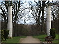
Pillars, Wallsend Hall Gardens, Wallsend
The area of land adjacent to Wallsend Dene probably began life as more open and scrubby land, but at some point it became enclosed as land for Wallsend Hall. The dene would have appealed to the landscaper's eye, as it was the fashion in the late 18th and early 19th centuries to create rugged, dramatic, picturesque gardens to be privately enjoyed by the most desirable houses. The dene was very secluded with no through roads, it provided water to manipulate for picturesque weirs, streams and bridges, plus bank sides to create rich tree belts and romantic woodland walks, and south facing slopes to exploit for sunny lawns, orchards and kitchen gardens. It would all have been laid out to be viewed and used from the hall plus its veranda, brow-top walk and summerhouse. ('The Green, Wallsend Conservation Area Character Appraisal' North Tyneside Council October 2006). These columns, which stand close to the hall overlooking the dene, are a remnant of the original gardens. These days, the dene is enjoyed by the general public. For a selection of detailed free to download walking routes in the area visit www.northtynesidewalks.co.uk
Image: © Geoff Holland
Taken: 9 Mar 2021
0.02 miles
3
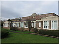
Wallsend Health Centre, Wallsend
Officially opened on 20th December 1940, this art décor style building which cost £22,000 to build is Grade II Listed. Built as part of a government scheme to provide 'model' facilities for mothers and young children, this building was affectionately known as the 'Sunray Clinic' as a consequence of the treatment used for the prevention of rickets. It is a stylish and perfectly proportioned building. For a selection of detailed free to download walking routes in the area visit www.northtynesidewalks.co.uk
Image: © Geoff Holland
Taken: 9 Mar 2021
0.03 miles
4

Parapet, Wallsend Health Centre, Wallsend
Officially opened on 20th December 1940, the art décor style Wallsend Health Centre which cost £22,000 to build is Grade II Listed. Built as part of a government scheme to provide 'model' facilities for mothers and young children, this building was affectionately known as the 'Sunray Clinic' as a consequence of the treatment used for the prevention of rickets. It is a stylish and perfectly proportioned building with a flat roof obscured by a brick parapet with a raised and stepped centre of stone. The stone bears the inscription BOROUGH/ OF/WALLSEND/HEALTH/CENTRE and immediately below this a rectangular recess edged in brick bears a hexagonal date stone reading AD/1940 and the base for a former fitting, possibly a sundial. For a selection of detailed free to download walking routes in the area visit www.northtynesidewalks.co.uk
Image: © Geoff Holland
Taken: 9 Mar 2021
0.04 miles
5
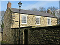
Lily Bank Cottage, Lily Bank, Wallsend
This early 19th century two storey house stands close to a sharp bend in Lily Bank and, at the rear, overlooks Wallsend Hall. It is a Grade II Listed building and is one of the oldest surviving properties in the area. For a selection of detailed free to download walking routes in the area visit www.northtynesidewalks.co.uk
Image: © Geoff Holland
Taken: 9 Mar 2021
0.04 miles
6
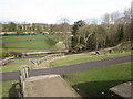
Wallsend Dene, Wallsend
This area of Wallsend Dene probably began life as more open and scrubby land, but at some point it became enclosed as land for Wallsend Hall. The dene would have appealed to the landscaper's eye, as it was the fashion in the late 18th and early 19th centuries to create rugged, dramatic, picturesque gardens to be privately enjoyed by the most desirable houses. The dene was very secluded with no through roads, it provided water to manipulate for picturesque weirs, streams and bridges, plus bank sides to create rich tree belts and romantic woodland walks, and south facing slopes to exploit for sunny lawns, orchards and kitchen gardens. It would all have been laid out to be viewed and used from the hall plus its veranda, brow-top walk and summerhouse. ('The Green, Wallsend Conservation Area Character Appraisal' North Tyneside Council October 2006). These days, it is enjoyed by the general public. For a selection of detailed free to download walking routes in the area visit www.northtynesidewalks.co.uk
Image: © Geoff Holland
Taken: 9 Mar 2021
0.05 miles
7
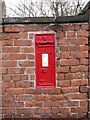
Post Box, Lily Bank, Wallsend
Roadside wall boxes first appeared in 1857 as a cheaper alternative to pillar boxes, especially in rural areas. This box dates from the reign of Queen Victoria (1837–1901) and is located in the boundary wall of Wallsend Hall which fronts onto Lily Bank. The box is shown on the Ordnance Survey Six-Inch map of the area published in 1898 (revised 1894 & 1895) marked 'L.B.'. For a selection of detailed free to download walking routes in the area visit www.northtynesidewalks.co.uk
Image: © Geoff Holland
Taken: 9 Mar 2021
0.05 miles
8

Crocodile Artwork, Wallsend Dene, Wallsend
This crocodile artwork, carved from a felled tree, lies on the steep southern slope of the dene, immediately behind Wallsend Hall. For a selection of detailed free to download walking routes in the area visit www.northtynesidewalks.co.uk
Image: © Geoff Holland
Taken: 9 Mar 2021
0.05 miles
9
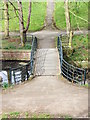
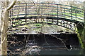
Decorative Bridge
Looking down towards the bridge over Wallsend Burn
Image: © Christine Westerback
Taken: 16 Mar 2012
0.05 miles