IMAGES TAKEN NEAR TO
Haggie Avenue, WALLSEND, NE28 7JQ
Introduction
This page details the photographs taken nearby to Haggie Avenue, NE28 7JQ by members of the Geograph project.
The Geograph project started in 2005 with the aim of publishing, organising and preserving representative images for every square kilometre of Great Britain, Ireland and the Isle of Man.

There are currently over 7.5m images from over14,400 individuals and you can help contribute to the project by visiting https://www.geograph.org.uk
Image Map
Images are licensed for reuse under creativecommons.org/licenses/by-sa/2.0
Notes
- Clicking on the map will re-center to the selected point.
- The higher the marker number, the further away the image location is from the centre of the postcode.
Image Listing (26 Images Found)
Images are licensed for reuse under creativecommons.org/licenses/by-sa/2.0
Image
Details
Distance

4
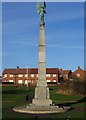
Wallsend War Memorial
Hidden by scrubby parkland, but with a wonderful view across the Tyne Valley, this memorial deserves to be better looked after. Surely a few shrubs and flowers would help...or are the authorities so cynical as to be believe it would be a wasted effort?
Image: © Alan Fearon
Taken: 16 Dec 2005
0.17 miles
5

Burn Bridge
Recently closed to road traffic, possibly to be demolished and rebuilt in the next few years.
Image: © Terry Wiley
Taken: 16 Jul 2006
0.18 miles
6
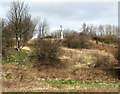
War Memorial
The memorial is near the slopes of Wallsend Dene - taken from the opposite square
Image: © Christine Westerback
Taken: 16 Mar 2012
0.18 miles
8

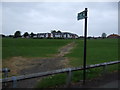
Houses above Wallsend Dene
Valley Gardens in Holy Cross.
Image: © Oliver Dixon
Taken: 4 Dec 2013
0.20 miles
9
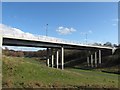
The New Burn Closes Bridge in Wallsend
This bridge, carrying the B1315 St. Peter's Road over Wallsend Burn in Wallsend, was constructed in 2008-09 to replace an older bridge at the same location.
For a photo of the old bridge being demolished, see:
Image
Image: © Andrew Tryon
Taken: 7 Mar 2012
0.21 miles
10
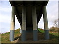
Burn Closes Bridge
Detail if underneath of bridge carrying the B1315
Image: © Christine Westerback
Taken: 16 Mar 2012
0.22 miles