IMAGES TAKEN NEAR TO
Savory Road, WALLSEND, NE28 7ED
Introduction
This page details the photographs taken nearby to Savory Road, NE28 7ED by members of the Geograph project.
The Geograph project started in 2005 with the aim of publishing, organising and preserving representative images for every square kilometre of Great Britain, Ireland and the Isle of Man.

There are currently over 7.5m images from over14,400 individuals and you can help contribute to the project by visiting https://www.geograph.org.uk
Image Map (12 Images)


Getting Data...Please wait
Leaflet Map data © OpenStreetMap
Images are licensed for reuse under creativecommons.org/licenses/by-sa/2.0
Notes
- Clicking on the map will re-center to the selected point.
- The higher the marker number, the further away the image location is from the centre of the postcode.
Image Listing (12 Images Found)
Images are licensed for reuse under creativecommons.org/licenses/by-sa/2.0
Image
Details
Distance
1
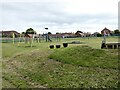
Children's Play Area at Willington
Sited in a green corridor.
Image: © Oliver Dixon
Taken: 6 Jul 2023
0.14 miles
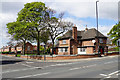
2
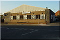
Archer Street Social Club
Formerly the British Legion Club
Image: © Mac McCarron
Taken: 20 Oct 2007
0.14 miles
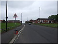
3
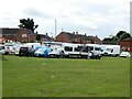
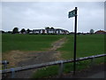
Major construction site off Archer Street
Understood to be construction of facilities for a youth club.
Image: © Oliver Dixon
Taken: 6 Jul 2023
0.15 miles
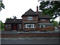
5
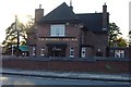
The Rosehill Tavern
A large pub on a corner plot.
Image: © Bill Boaden
Taken: 20 Apr 2017
0.21 miles
8
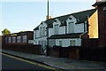
The Engine
The original pub was the white building, the named building is a later extension.
Image: © Mac McCarron
Taken: 20 Oct 2007
0.21 miles
10
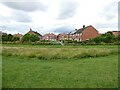
Whitby Gardens
Housing estate and open space in Willington
Image: © Oliver Dixon
Taken: 6 Jul 2023
0.23 miles