IMAGES TAKEN NEAR TO
Burn Closes Crescent, WALLSEND, NE28 7BP
Introduction
This page details the photographs taken nearby to Burn Closes Crescent, NE28 7BP by members of the Geograph project.
The Geograph project started in 2005 with the aim of publishing, organising and preserving representative images for every square kilometre of Great Britain, Ireland and the Isle of Man.

There are currently over 7.5m images from over14,400 individuals and you can help contribute to the project by visiting https://www.geograph.org.uk
Image Map (Loading...)


Getting Data...Please wait
Leaflet Map data © OpenStreetMap
Images are licensed for reuse under creativecommons.org/licenses/by-sa/2.0
Notes
- Clicking on the map will re-center to the selected point.
- The higher the marker number, the further away the image location is from the centre of the postcode.
Image Listing (49 Images Found)
Images are licensed for reuse under creativecommons.org/licenses/by-sa/2.0
Image
Details
Distance
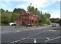
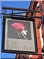
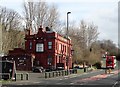
4
Bus passing the Rose Inn
This pub is on Rosehill Bank, on the east side of Wallsend. The pub was built just before WW1 to replace an earlier one. Seems to be empty at the moment.
Image: © Robert Graham
Taken: 9 Mar 2020
0.10 miles
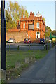
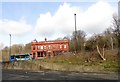
6

The Rose Inn
A closed pub and fine building on Rosehill. It is somewhat isolated from other buildings. Looking at old Streetview images, it appeared to have closed around 2010. All the Streetview images show the green shades which were still here in 2015.
Image: © Richard Webb
Taken: 1 Oct 2015
0.10 miles
7
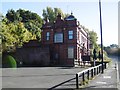
The Rose Inn
A closed pub and fine building on Rosehill. It is somewhat isolated from other buildings. Looking at old Streetview images, it appeared to have closed around 2010.
Image: © Richard Webb
Taken: 1 Oct 2015
0.10 miles
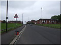
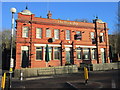
8
The Rose Inn, Wallsend
This pub dates to 1913, when it replaced an earlier pub called The Rose which is shown on the 1865 Ordnance Survey map. This is a very ornate building in terracotta, which is quite a rare example in the area. There is only one other terracotta pub in Wallsend. Sadly, it appears to be unused as a pub at the present, although the first floor has been converted into flats. The bus is about to climb Rosehill Bank.
Image: © Robert Graham
Taken: 9 Mar 2020
0.10 miles