IMAGES TAKEN NEAR TO
Oak Grove, WALLSEND, NE28 6PW
Introduction
This page details the photographs taken nearby to Oak Grove, NE28 6PW by members of the Geograph project.
The Geograph project started in 2005 with the aim of publishing, organising and preserving representative images for every square kilometre of Great Britain, Ireland and the Isle of Man.

There are currently over 7.5m images from over14,400 individuals and you can help contribute to the project by visiting https://www.geograph.org.uk
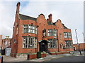
Image Map (Loading...)


Getting Data...Please wait
Leaflet Map data © OpenStreetMap
Images are licensed for reuse under creativecommons.org/licenses/by-sa/2.0
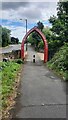
Notes
- Clicking on the map will re-center to the selected point.
- The higher the marker number, the further away the image location is from the centre of the postcode.
Image Listing (64 Images Found)
Images are licensed for reuse under creativecommons.org/licenses/by-sa/2.0
Image
Details
Distance
3
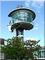
Viewing Platform
A birdseye view of Segedunum Roman Fort and Baths in Wallsend
Image: © Christine Westerback
Taken: 13 Aug 2005
0.11 miles
4
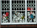
Looking Out
Couldn't resist this. Masks peering from an office window on the road down to Wallsend Slipway
Image: © Christine Westerback
Taken: 13 Aug 2005
0.11 miles
5
Segedunum Roman Fort and Baths
Occupied for some 300 years, the site had buildings on for 200 years. The last buildings were demolished in the early 70s and the area preserved. An observation tower makes sense of the area.
Image: © Christine Westerback
Taken: 14 Aug 2005
0.11 miles
6
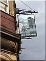
The New Winning
Built in 1894. I couldn't take a photo of the public house as I was following behind a group of children that were off to a nearby swimming pool so obviously a photo was out of the question!
Image: © Christine Westerback
Taken: 16 Mar 2012
0.12 miles
7
Wallsend Engineer's Club
This building was originally the Coach Road branch of Wallsend Co-op then a printing works and now a CIU club.
Image: © Mac McCarron
Taken: 8 Oct 2007
0.13 miles
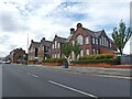
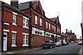
8
The Coach and Horses, High Street East, Wallsend
The council offices extend into the first floor of the pub
Image: © Mac McCarron
Taken: 7 Oct 2007
0.14 miles
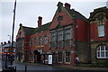
9
Coach and Horses, Wallsend
Built c1907 for W B Reed and Co, brewers, to the design of the company's architect Watson. It is listed Grade II.
Image: © Anthony Foster
Taken: 18 Jun 2014
0.14 miles
10
Hadrian's Cycleway Arch
This arch is on National Cycle Network route 72
Image: © Clive Nicholson
Taken: 24 Jul 2022
0.15 miles