IMAGES TAKEN NEAR TO
Quay View, WALLSEND, NE28 6JT
Introduction
This page details the photographs taken nearby to Quay View, NE28 6JT by members of the Geograph project.
The Geograph project started in 2005 with the aim of publishing, organising and preserving representative images for every square kilometre of Great Britain, Ireland and the Isle of Man.

There are currently over 7.5m images from over14,400 individuals and you can help contribute to the project by visiting https://www.geograph.org.uk
Image Map (Loading...)


Getting Data...Please wait
Leaflet Map data © OpenStreetMap
Images are licensed for reuse under creativecommons.org/licenses/by-sa/2.0
Notes
- Clicking on the map will re-center to the selected point.
- The higher the marker number, the further away the image location is from the centre of the postcode.
Image Listing (36 Images Found)
Images are licensed for reuse under creativecommons.org/licenses/by-sa/2.0
Image
Details
Distance
1
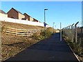
Cycle route behind Hadrian Road
National Cycle Network route 72 (eastern end of Hadrian's Cycleway). A new housing estate has been recently built on the uphill side.
Image: © Oliver Dixon
Taken: 4 Dec 2013
0.09 miles
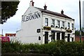
2
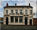
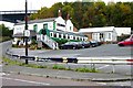
Albion Inn
The Albion Inn at Willington Quay.
Image: © Peter McDermott
Taken: 21 Sep 2010
0.10 miles
6
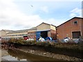
Ropeworks at Willington Quay
There has been a rope works here since the 18th century. The modern factory is owned by Bridon International who produce wire ropes for industrial use. In times gone by, the quay here was used by barges.
Image: © Robert Graham
Taken: 9 Mar 2020
0.12 miles
7

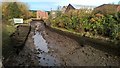
Willington Gut
View looking up Willington Gut towards Willington Mill.
Image: © Peter McDermott
Taken: 21 May 2011
0.12 miles
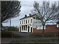
8
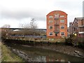
The old mill at Willington Quay
This is located on the banks of Willington Gut, beside the present Bridon ropeworks. Originally built around 1750, it was of 7 storeys, as shown on an old photo dated 1893. Since then however, it has been cut down to 4 storeys and a curved roof put on.
Image: © Robert Graham
Taken: 9 Mar 2020
0.13 miles
9
Willington Gut, looking north
However, the magnificent viaduct in the background is worthy of greater note as it was built as long ago as 1837 when railways were still very new, as were iron bridges. I'd hoped to get a clear view of the viaduct, but trees seemed to be much higher than when I last came this way. Here it is in earlier days; http://www.geograph.org.uk/photo/246914
Image: © Chris Morgan
Taken: 30 Oct 2016
0.14 miles
10
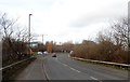
Hadrian Road at Willington Quay
Willington Quay is on the eastern edge of Wallsend, on the east side of the stream known as the Gut. This view looks down to the bridge over the Gut - note the boats in the yard on the left.
Image: © Robert Graham
Taken: 9 Mar 2020
0.14 miles