IMAGES TAKEN NEAR TO
Vine Street, WALLSEND, NE28 6JF
Introduction
This page details the photographs taken nearby to Vine Street, NE28 6JF by members of the Geograph project.
The Geograph project started in 2005 with the aim of publishing, organising and preserving representative images for every square kilometre of Great Britain, Ireland and the Isle of Man.

There are currently over 7.5m images from over14,400 individuals and you can help contribute to the project by visiting https://www.geograph.org.uk
Image Map
Images are licensed for reuse under creativecommons.org/licenses/by-sa/2.0
Notes
- Clicking on the map will re-center to the selected point.
- The higher the marker number, the further away the image location is from the centre of the postcode.
Image Listing (148 Images Found)
Images are licensed for reuse under creativecommons.org/licenses/by-sa/2.0
Image
Details
Distance
1
Council Offices, Park Road, Wallsend
This building housed the original Coronation Club
Image: © Mac McCarron
Taken: 7 Oct 2007
0.05 miles
2
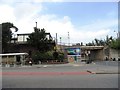
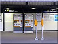
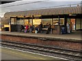
Bus and Metro Stations at Wallsend
The two public transport stations in Wallsend are placed next to each other, to the great convenience of passengers. As can be seen, the Metro platform is a bit of a climb up, although there is a long ramp further along.
Image: © Robert Graham
Taken: 24 Jul 2013
0.06 miles
7
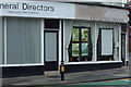
'Go As You Please'
Offers funerals with a difference
Image: © Mac McCarron
Taken: 7 Oct 2007
0.08 miles