IMAGES TAKEN NEAR TO
Railway Terrace, WALLSEND, NE28 6HZ
Introduction
This page details the photographs taken nearby to Railway Terrace, NE28 6HZ by members of the Geograph project.
The Geograph project started in 2005 with the aim of publishing, organising and preserving representative images for every square kilometre of Great Britain, Ireland and the Isle of Man.

There are currently over 7.5m images from over14,400 individuals and you can help contribute to the project by visiting https://www.geograph.org.uk
Image Map
Images are licensed for reuse under creativecommons.org/licenses/by-sa/2.0
Notes
- Clicking on the map will re-center to the selected point.
- The higher the marker number, the further away the image location is from the centre of the postcode.
Image Listing (31 Images Found)
Images are licensed for reuse under creativecommons.org/licenses/by-sa/2.0
Image
Details
Distance
1
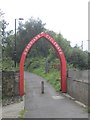
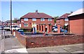
Hadrian's Cycleway
An arch at the start of a disused railway section of the cycle path between Wallsend and Newcastle City Centre. Route 72 carries on along the course of the Wall to the Solway.
This section of the route was busy with commuters.
Image: © Richard Webb
Taken: 31 Jul 2012
0.03 miles

3
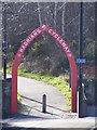
Hadrian Cycleway
The Hadrian Cycleway runs east-west through North Tyneside and forms part of the National Cycle Network Route 72 (the Coast to Coast route).
Image: © Andrew Tryon
Taken: 7 Mar 2012
0.03 miles
4
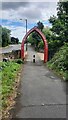
Hadrian's Cycleway Arch
This arch is on National Cycle Network route 72
Image: © Clive Nicholson
Taken: 24 Jul 2022
0.03 miles
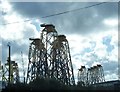
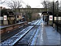
7
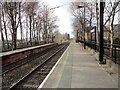
View west along the Metro line at Hadrian Road
Hadrian Road Metro Station is on a long straight stretch of the railway, as can be seen here. This line dates originally to 1839, but was converted to the Tyneside Metro light railway in 1980-84.
Image: © Robert Graham
Taken: 9 Mar 2020
0.17 miles
8
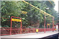
Hadrian Rd Metro station
Photo 6 of a series of 9, showing the metro stations between Tynemouth and Chillingham rd (Newcastle)
Image: © hayley green
Taken: 31 Aug 2009
0.18 miles
9
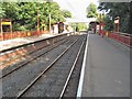
Hadrian Road Metro station, Tyne & Wear
Opened in 1982 by the Tyne & Wear Metro on the line from Newcastle to Tynemouth.
View east towards Howdon and Tynemouth.
Image: © Nigel Thompson
Taken: 17 Sep 2010
0.19 miles
10
Hadrian Road Metro Station (looking east)
Image: © Andrew Curtis
Taken: 18 Jan 2018
0.19 miles