IMAGES TAKEN NEAR TO
Sandholm Close, WALLSEND, NE28 0RB
Introduction
This page details the photographs taken nearby to Sandholm Close, NE28 0RB by members of the Geograph project.
The Geograph project started in 2005 with the aim of publishing, organising and preserving representative images for every square kilometre of Great Britain, Ireland and the Isle of Man.

There are currently over 7.5m images from over14,400 individuals and you can help contribute to the project by visiting https://www.geograph.org.uk
Image Map (Loading...)


Getting Data...Please wait
Leaflet Map data © OpenStreetMap
Images are licensed for reuse under creativecommons.org/licenses/by-sa/2.0
Notes
- Clicking on the map will re-center to the selected point.
- The higher the marker number, the further away the image location is from the centre of the postcode.
Image Listing (19 Images Found)
Images are licensed for reuse under creativecommons.org/licenses/by-sa/2.0
Image
Details
Distance
1
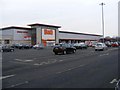
B & Q - Willington Square
Built on the site of a former factory manufacturing oil seals.
Image: © Mac McCarron
Taken: 30 Jan 2009
0.12 miles

3
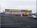
Safestore - Willington Square
Storage facility.
Image: © Mac McCarron
Taken: 31 Jan 2009
0.14 miles
5
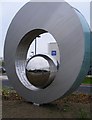
Sculpture (2) - Northumbria Police North Tyneside Area Command HQ
The stainless steel sphere reflects the words inscribed on the inner surface of the ring. The words are a list of the qualities of the police force.
Image: © Mac McCarron
Taken: 11 Apr 2011
0.18 miles
6
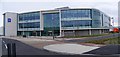
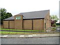
Northumbria Police - North Tyneside Area Command HQ
This is a panoramic view of the main building. There are other subsidiary buildings to the rear.
Image: © Mac McCarron
Taken: 11 Apr 2011
0.18 miles
7
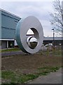
Sculpture (1) - Northumbria Police, North Tyneside Area Command HQ
The symbolism of this work, if there is any, is lost on me. There are words inscribed on the inner surface of the ring and these words can be seen in close-up in Sculpture (2).
Image: © Mac McCarron
Taken: 11 Apr 2011
0.18 miles
8
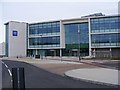
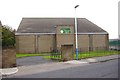
Northumbria Police - North Tyneside Area Command HQ
A new police station for North Tyneside to replace the old police station in Alexandra Street, Wallsend.
Image: © Mac McCarron
Taken: 11 Apr 2011
0.18 miles
9
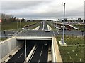
A19 interchange with A1058
The east-west A1058 Coast Road was constructed to dual carriageway standard in the late 1960s between Heaton and Billy Mill with grade separated junctions.
The north-south Tyne Tunnel Approach Roads were constructed around the same time either side of the tunnel between the A1 at Seaton Burn to the North and the Testo's Roundabout to the south and numbered A108.
In 1979 the Tyne Tunnel Approach Roads were trunked and re-numbered A1, although the Tunnel was not trunked and remains a tolled estuarial crossing.
Following the completion of the Newcastle Western Bypass in December 1990 the Tyne Tunnel Approach Roads were re-numbered A19.
The junction with the A1058 was a significant bottleneck for north-south traffic. A grade separated dive-under was completed in March 2019 to address this.
Image: © Anthony Foster
Taken: 7 Dec 2019
0.18 miles